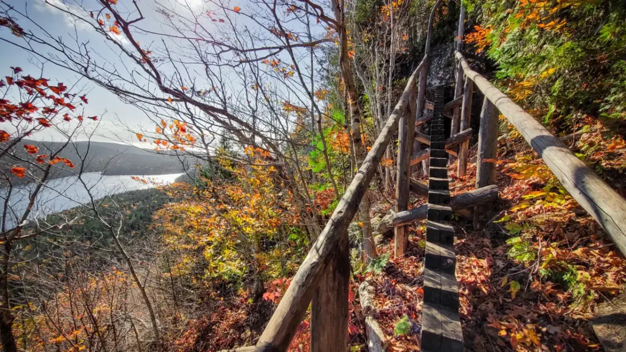
John Manard / Wikimedia Commons, CC BY-SA 2.0; cropped from the original. Source · CC BY-SA 2.0
Acadia packs an unusual amount of variety into a small park. One morning can begin on granite ledges above the Atlantic, continue through spruce woods beside a clear glacial pond, and finish on an open summit. Together, these 29 trails cover the park’s essential terrain. Some are short and exposed. Others trade iron rungs for steady miles, quiet forest, carriage roads, or long coastal views.
Choosing among the best hikes in Acadia National Park is easier when the trails are grouped by location. That also makes it simpler to build a day around parking and the Island Explorer bus. Distances and times describe the routes as presented here. Elevation profiles use measured route geometry, so their mileage may differ slightly from the rounded planning distances in the guide. Conditions can change quickly, especially on open granite, so choose by terrain and weather rather than mileage alone. A short ladder route can demand more focus than a much longer mountain walk.
Plan before you reach the trailhead
Keep the first choice flexible. A full parking lot, wet granite, strong wind, or a wildlife closure can change the right hike for the day. Carry one exposed-route plan and one lower alternative.
Entrance passes and trail permits
A park entrance pass is required throughout Acadia, including when a trail begins beside a public road. Display or carry the pass as directed. None of the hikes on this page requires a separate hiking permit. A Cadillac Summit Road vehicle reservation does not replace the park entrance pass.
Cadillac Summit Road reservations in 2026
Vehicle reservations are required to drive Cadillac Summit Road from May 20 through October 25, 2026. The reservation applies only to vehicles entering the summit road. Hikers who start below the gate on Cadillac South Ridge Trail or Cadillac North Ridge Trail do not need a summit road vehicle reservation. They still need a park entrance pass. There is no Island Explorer pickup at the Cadillac summit, so do not plan a one-way hike that depends on catching a bus at the top.
Parking and the Island Explorer
Parking is often the least predictable part of an Acadia hike. Sand Beach, Jordan Pond, Bubbles, and the small roadside mountain lots can fill early. Never wait in a travel lane or stop outside marked spaces. The free Island Explorer is usually the simplest answer for the east-side trails when it is in seasonal service. Bubbles Divide is an exception because buses do not stop there. Check the day’s route schedule before leaving because the last bus and stop pattern can affect a point-to-point plan.
Weather, granite, and exposed routes
Acadia granite becomes slick in rain, fog, frost, and sea spray. Save the Beehive and Precipice for a dry forecast. Turn around if the rock is wet or wind makes balance uncertain. Open summits can be cooler and far windier than the trailhead. Carry water, a warm layer, rain protection, and a headlamp even on a short outing. Cell service is inconsistent, so download a map before entering the park.
Dogs on Acadia trails
Pets must be leashed on trails where they are allowed. The Beehive and Precipice do not allow pets because the routes use iron rungs, narrow ledges, and steep climbing. Pemetic Mountain, Beech Cliff, and Perpendicular Trail also have route-specific pet restrictions, so check each trail’s facts before setting out. Sand Beach is also closed to pets from June 15 through September 8, which affects the usual beach approach to Great Head. On other trails, legal access does not mean the terrain suits every dog. Hot granite, sharp rock, crowded boardwalks, and steep scrambles can cause trouble. Carry water, keep the leash short near cliffs and wildlife, and pack out all waste.
Sand Beach and Ocean Drive
These five hikes share the park's busiest coastal corridor. The Island Explorer makes it possible to leave the car outside the most crowded lots, and several routes can be combined. Start early if a specific parking space matters. For a slower day, choose one mountain route and add a section of Ocean Path instead of racing between trailheads.
| Trail | Distance | Time | Difficulty | Best for |
|---|---|---|---|---|
| Beehive Loop | 1.4 miles | 1 to 3 hours | Hard | Iron rungs and exposed views above Sand Beach |
| Precipice Loop | 3.2 miles | 2 to 3 hours | Hard | Acadia's most sustained iron-rung climb |
| Gorham Mountain Loop | 3.5 miles | 1 to 3 hours | Moderate | Ocean views without a major ladder ascent |
| Ocean Path | 4.4 miles | 2 to 4 hours | Easy | Continuous access to the rocky coast |
| Great Head Trail | 1.9 miles | 2 to 4 hours | Moderate | Headland views above Sand Beach |
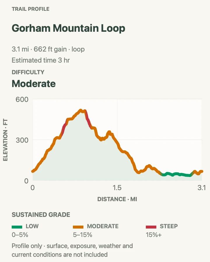
Beehive Loop
- Distance
- 1.4 miles
- Elevation gain
- 514 feet
- Time
- 1 to 3 hours
- Difficulty
- Hard
- Route type
- Loop
- Parking
- Sand Beach lot or marked right-lane parking on Park Loop Road; Island Explorer routes 3 and 4 serve the area
- Best time
- Early morning on a dry, calm day
- Pets
- Not allowed
The Beehive is short on mileage and big on commitment. The climb rises quickly from the Bowl Trail junction, using iron rungs, handholds, and narrow granite shelves to reach open ledges above Sand Beach. There is real exposure, and the route requires steady hands as well as feet. It is a poor choice for anyone uneasy with heights, young children who cannot follow directions closely, or hikers wearing bulky packs.
Travel uphill on the rung section. Trying to descend against climbing traffic creates unnecessary risk and congestion. From the top, continue to the Bowl and return on the Bowl Trail for a safer, more comfortable descent. The summit is not the only reward. Pause where the trail widens to look across Frenchman Bay and down to the pale curve of Sand Beach.
Arrive early enough to avoid a line at the first rungs, but do not start in darkness unless the route is familiar. Morning light is attractive on the water, and the rock is often cooler before midday. Skip the climb after rain or when fog leaves the granite damp. Wear shoes with reliable grip and keep both hands free. Trekking poles are more nuisance than help on the ascent, though collapsible poles can be useful on the descent.

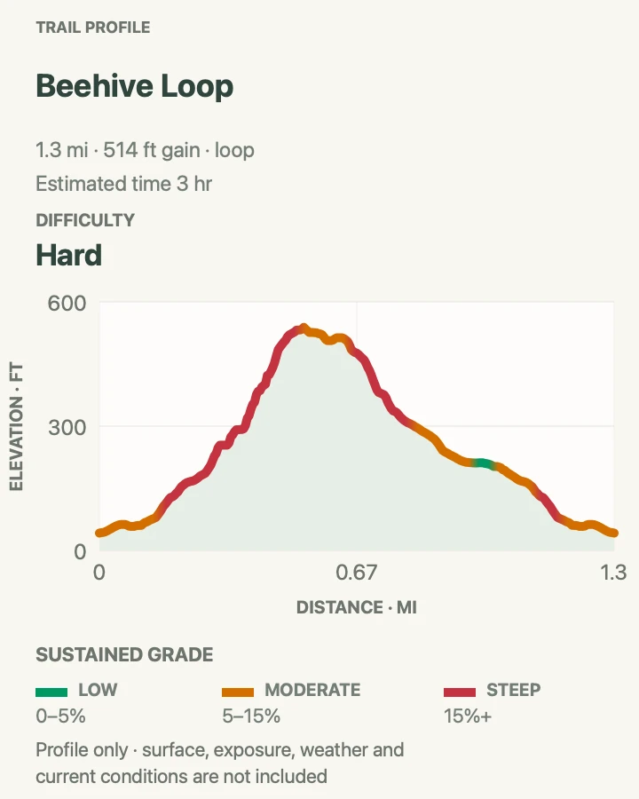
Precipice Loop
- Distance
- 3.2 miles
- Elevation gain
- 1,108 feet
- Time
- 2 to 3 hours
- Difficulty
- Hard
- Route type
- Loop
- Parking
- Precipice lot when the trail and lot are open; no Island Explorer route stops here
- Best time
- A cool, dry morning when the trail is open
- Pets
- Not allowed
Precipice is Acadia’s most sustained iron-rung route. It climbs the east face of Champlain Mountain through a sequence of ledges, ladders, narrow passages, and exposed traverses. The climbing is not technical in the rock-climbing sense, but a fall could have severe consequences. Once started, the route offers few easy places to step aside or reverse direction.
When the trail is open, climb Precipice and return by the Champlain North Ridge Trail and Orange and Black Path. This keeps traffic moving in the intended direction and avoids descending the main ladder route. A small pack is easier to manage through tight spots. Secure phones, bottles, and loose gear before the first steep section, and leave trekking poles packed until the descent.
Dry rock and low wind matter more than the clock. A cool morning is preferable because the face is exposed to the sun and physical effort begins almost immediately. When a nesting closure is active, the trail remains off limits until the park reopens it. The nearby Beehive is not a substitute during wet weather because it has similar granite and exposure concerns.

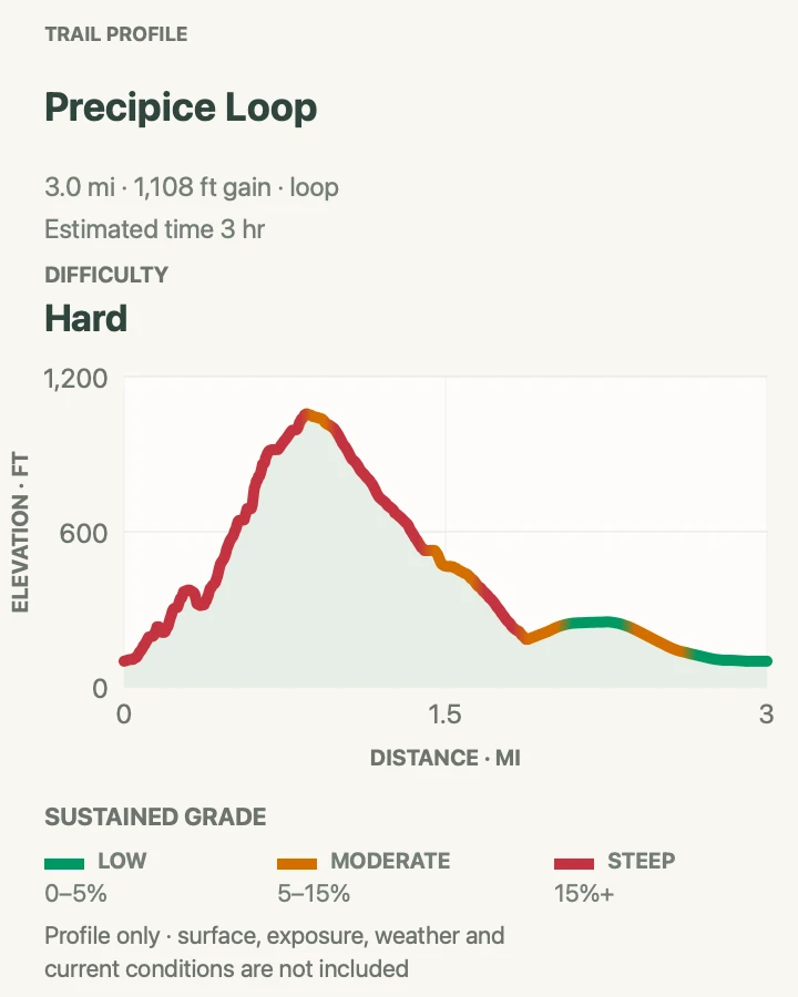
Gorham Mountain Loop
- Distance
- 3.1 to 3.5 miles, depending on the return
- Elevation gain
- 662 feet
- Time
- 1 to 3 hours
- Difficulty
- Moderate
- Route type
- Loop
- Parking
- Gorham Mountain lot on Park Loop Road, south of Thunder Hole
- Best time
- Morning or late afternoon in dry weather
- Pets
- Allowed on leash on the main route; skip the Cadillac Cliffs detour with a dog
Gorham Mountain delivers open coastal views without the sustained exposure of the Beehive or Precipice. The route still feels unmistakably Acadian. It climbs through pitch pine and spruce, crosses broad granite slabs, and reaches ledges with a clear view toward Sand Beach, Great Head, and the Cranberry Isles. Blazes can be harder to spot on bare rock, so look ahead before choosing a line.
The Cadillac Cliffs spur adds narrow passages, rough scrambling, and a few iron aids. Take it only when the rock is dry and everyone in the group wants the extra challenge. The main Gorham Mountain Trail is the better choice for a steadier climb. The exact mileage changes with the chosen connector and coastal return. Either way, keep following the marked route rather than cutting across thin soil and low vegetation.
The parking lot is small and easy to pass on the one-way section of Park Loop Road. If it is full, continue to a legal space instead of circling or stopping in the roadway. An early start gives the ledges a quieter feel. Late afternoon can also be pleasant after coastal crowds thin, but allow enough daylight for the descent. Add Ocean Path if more mileage sounds appealing, or keep the loop compact when fog, heat, or tired legs make a longer day unwise.

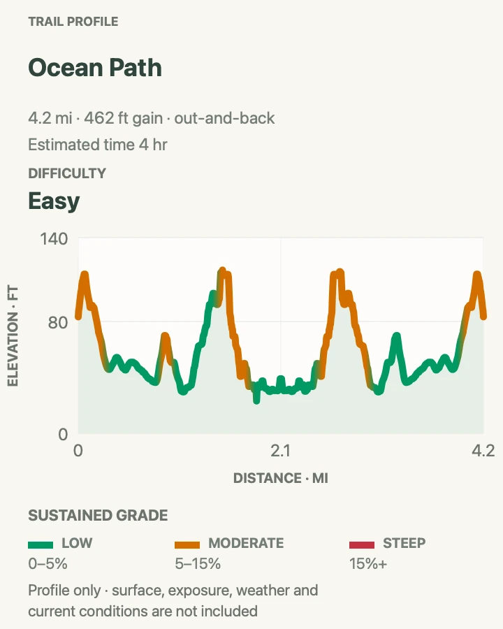
Ocean Path
- Distance
- 4.4 miles out and back
- Elevation gain
- 462 feet
- Time
- 2 to 4 hours
- Difficulty
- Easy
- Route type
- Out and back, with one-way options when the Island Explorer is running
- Parking
- Sand Beach, Thunder Hole, or the Otter Cliff and Fabbri area; several Island Explorer stops serve the corridor
- Best time
- Early morning for quiet, or one to two hours before high tide for Thunder Hole when sea conditions cooperate
- Pets
- Allowed on leash on Ocean Path; Sand Beach is closed to pets from June 15 through September 8
Ocean Path follows the pink-granite shore from Sand Beach toward Otter Point, passing Thunder Hole and the tall sea cliffs near Otter Cliff. It is the most accessible way to spend several hours close to Acadia’s rocky coast without committing to a mountain climb. The trail rolls gently, but roots, rocks, and short uneven stretches still call for better shoes than a paved promenade would.
Thunder Hole is not guaranteed to thunder. The effect depends on tide, swell, wind, and the direction of the waves. Stay behind barriers and keep well back from wet ledges. A calm-looking ocean can send a much larger wave over the rocks, especially during storms or heavy surf. Do not climb down for a photograph.
Walking one way and returning by Island Explorer can reduce repetition, but confirm the active stops and final pickup before starting. A relaxed out-and-back works just as well because each direction reveals different angles of the coves and islands. Morning usually brings fewer people around Sand Beach and Thunder Hole. Fog can mute the long view while making the spruce-lined shore atmospheric, but it also makes rock slick and reduces visibility near cliff edges.

Great Head Trail
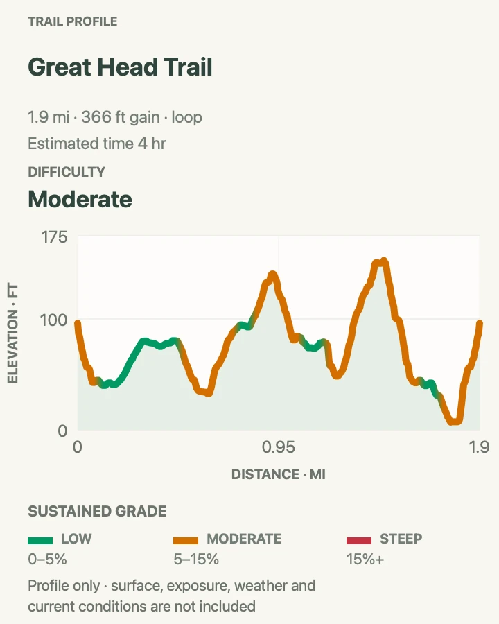
- Distance
- 1.9 miles
- Elevation gain
- 366 feet
- Time
- 2 to 4 hours
- Difficulty
- Moderate
- Route type
- Loop
- Parking
- Small Great Head parking loop off Schooner Head Road; Sand Beach is an alternate start and Island Explorer stop
- Best time
- Morning, before the Sand Beach area becomes busy
- Pets
- Allowed on leash on the trail; use the Schooner Head Road start when Sand Beach is closed to pets from June 15 through September 8
Great Head circles a granite headland above the Atlantic. The route shown here starts at the small Great Head parking loop off Schooner Head Road, descends toward the beach-side junction, and circles the headland back to the parking connector. The rough section above the east end of Sand Beach crosses rock that can be slick with moisture and beach grit. Elsewhere, the route alternates between woods, open ledges, and broad viewpoints over the beach, the Beehive, and offshore islands.
A counterclockwise circuit puts the initial scramble on the ascent, where it is easier to see and manage. The loop is more rugged than its short distance suggests. Roots, irregular stone steps, and frequent viewpoints slow the pace, which helps explain the conservative time estimate. There is little shade on the outer headland, so bring water even when the sea breeze feels cool.
Visitors can also begin at Sand Beach, cross the sand, and climb from its east end. Start early for the easiest parking and a quieter beach. The Schooner Head Road trailhead is the practical summer start for hikers with dogs because Sand Beach is closed to pets from June 15 through September 8. Pay attention at open ledges, where informal tracks can lead toward cliff edges or fragile vegetation. A dry inland morning does not guarantee dry rock here because fog and spray linger along the headland.

Bar Harbor and Sieur de Monts
These walks and climbs begin close to Bar Harbor or the Sieur de Monts park entrance. They range from a tide-dependent gravel crossing to steep historic stone paths. Parking is limited at the smaller trailheads, and the Island Explorer is often the easiest way to reach Sieur de Monts.
| Trail | Distance | Time | Difficulty | Best for |
|---|---|---|---|---|
| Bar Island Trail | 2 miles | 1 to 2 hours | Easy | A walkable gravel land bridge that emerges from Frenchman Bay at low tide. |
| Compass Harbor Trail | 0.7 miles | 30 to 60 minutes | Easy | The forested ruins of George B. Dorr's Oldfarm estate beside a cobblestone harbor. |
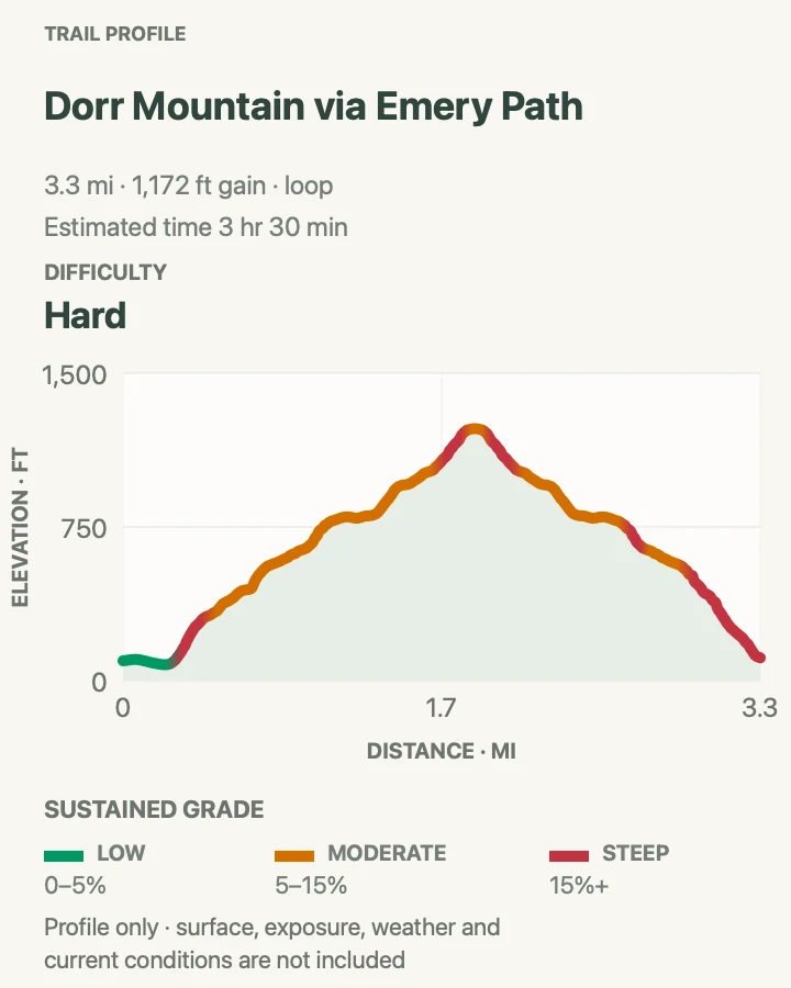
| Dorr Mountain via Emery Path | 3.4 miles | 2 to 3.5 hours | Hard | Intricate memorial-path stonework climbing from Sieur de Monts to Dorr Mountain's exposed ridge. |
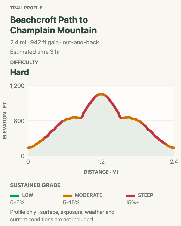
| Beachcroft Path to Champlain Mountain | 2.4 miles | 2 to 3 hours | Hard | A historic granite stairway leading to broad coastal views from Champlain Mountain. |
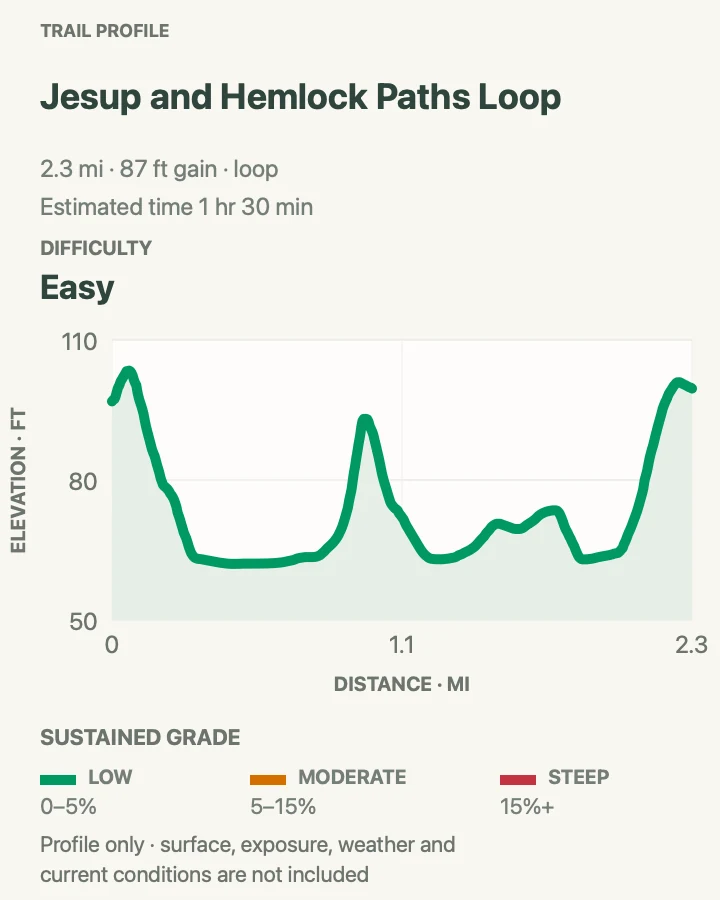
| Jesup and Hemlock Paths Loop | 2.3 miles | 45 to 90 minutes | Easy | A raised boardwalk through birch wetlands with open views across Great Meadow. |
Bar Island Trail
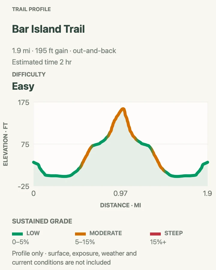
- Distance
- 2 miles
- Elevation gain
- 195 feet
- Time
- 1 to 2 hours
- Difficulty
- Easy
- Route type
- Out and back
- Parking
- There is no dedicated trail lot. Use legal public parking in Bar Harbor and walk to the foot of Bridge Street; arrive early because nearby spaces fill quickly.
- Best time
- Begin near the start of the low-tide access window, ideally in the morning for lighter crowds and easier parking.
- Pets
- Leashed pets are allowed. Keep the leash no longer than 6 feet and avoid letting pets disturb wildlife in the intertidal zone.
Bar Island Trail begins in downtown Bar Harbor with a walk across the broad gravel bar that appears at low tide. The crossing itself is half the fun: tide pools gather between cobbles, boats settle lower in the harbor, and the town slowly recedes behind you. Once on the island, an old road climbs gently through spruce and hardwood forest. A short side path near the high point opens a clearer view back toward Bar Harbor and the Porcupine Islands than the wooded summit does.
This is an easy outing, but it demands more planning than many harder hikes. The land bridge is normally passable only for about 90 minutes before and after low tide, and the water can return faster than it seems. Check the Bar Harbor tide table for the exact day, note when you step onto the bar, and leave a generous margin for the return. Early in the access window usually means a calmer crossing and an easier search for parking. Wear shoes that can handle wet stones and mud, especially if you want to explore the edges of the bar.
Trail tip: Save the tide time on your phone and set a turnaround alarm before leaving the mainland.

Compass Harbor Trail
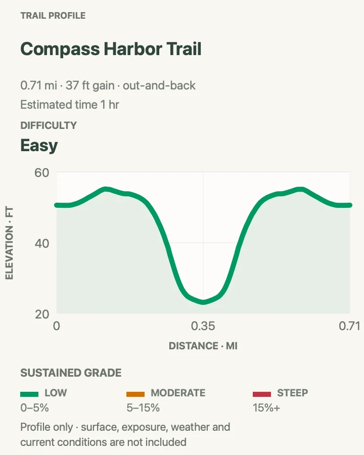
- Distance
- 0.7 miles
- Elevation gain
- 37 feet
- Time
- 30 to 60 minutes
- Difficulty
- Easy
- Route type
- Out and back
- Parking
- A small, unmarked gravel lot sits on Route 3 just north of Schooner Road. Display a valid park pass and keep the metal fire-road gate clear.
- Best time
- Morning or late afternoon, when the small lot is less likely to be full and low-angle light reaches the harbor.
- Pets
- Leashed pets are allowed. Use a leash no longer than 6 feet.
Compass Harbor feels surprisingly secluded for a walk that begins about a mile from downtown Bar Harbor. The path enters a white-pine and mixed hardwood forest, circles toward a cobblestone shore, and passes the remains of Oldfarm, the former estate of George B. Dorr. Granite steps, a house foundation, garden remnants, and traces of a saltwater pool lend the route a quiet, half-reclaimed atmosphere. At the water, the view reaches across Compass Harbor toward Frenchman Bay and the islands beyond. Low tide adds small pools among the cobbles.
The opening stretch is broad and fairly level, but the approach to the shore becomes rougher, with roots, rocks, a steeper grade, and a run of large stone steps. Allow time to explore rather than treating it as a quick dash to the beach. The unsigned parking entrance is easy to pass, so slow down as Route 3 approaches Schooner Road and look for the small gravel lot and metal gate. Do not block the gate. If the lot is full, walking from Bar Harbor is often less frustrating than circling on the highway.
Trail tip: Download the Oldfarm tour before leaving town if you want context for the foundations and landscape remnants.

Dorr Mountain via Emery Path
- Distance
- 3.4 miles
- Elevation gain
- 1,172 feet
- Time
- 2 to 3.5 hours
- Difficulty
- Hard
- Route type
- Loop
- Parking
- Use the Sieur de Monts parking area near the Nature Center. Spaces are limited from roughly 9 am to 3 pm in summer; the Island Explorer serves this stop.
- Best time
- A dry morning in spring, summer, or fall, before the parking area and stone steps become busy.
- Pets
- Leashed pets are allowed, but the very steep granite stairs and exposed sections make the route unsuitable for many dogs.
This Dorr Mountain loop begins at Sieur de Monts with one of Acadia's finest historic stairways. Emery Path climbs quickly through forest on carefully fitted granite steps and narrow passages, then Schiff Path rises along the mountain's east face with views toward the Tarn and Frenchman Bay. The upper trail leaves the trees for exposed granite before reaching Dorr's long summit ridge. A return by Kurt Diederichs Climb brings another steep sequence of stonework back toward the spring.
The route is strenuous despite its compact distance. Hundreds of steps, rough ledges, and sustained climbing demand sturdy shoes and patient pacing. The stone becomes treacherous when wet, so save this hike for a dry day and descend slowly. Shade disappears near the upper ridge. Dogs are allowed but are not well suited to the steep stairs and exposed rock. Sieur de Monts parking is limited during peak daytime hours, while the Island Explorer provides a much easier arrival in season. Leave time after the hike for the spring, nature center, or Wild Gardens rather than treating the trailhead only as a parking stop.
Trail tip: Ascend Emery Path and take time on the descent, when tired legs make the long granite stairways feel steepest.

Beachcroft Path to Champlain Mountain
- Distance
- 2.4 miles
- Elevation gain
- 942 feet
- Time
- 2 to 3 hours
- Difficulty
- Hard
- Route type
- Out and back
- Parking
- A small trailhead lot sits on Route 3 across from the Tarn. Alternatively, use the Island Explorer to Sieur de Monts and add the Wild Gardens Path connection.
- Best time
- A clear, dry morning before the exposed granite heats up.
- Pets
- Leashed pets are allowed. Use a leash no longer than 6 feet, but consider the steep ledges and scrambling before bringing a dog.
Beachcroft Path reaches Champlain Mountain without the iron ladders of the neighboring Precipice route. From Route 3, cut granite stairs and fitted stone paths climb the flank of Huguenot Head above the Tarn. After a brief dip, the route ascends broad granite ledges toward Champlain's 1,058-foot summit. The reward is a panoramic look over Frenchman Bay, the outlying islands, Bar Harbor, and the steep east face of Dorr Mountain.
This is still a hard hike. The climb gains elevation quickly, includes short scrambles, and spends long stretches on exposed rock. Cairns and blue blazes can be harder to follow in fog, while rain turns the granite slick enough to make retreat the wiser choice. Start early to avoid heat and traffic at the small Route 3 lot. Midday sun can feel intense on the slabs. If parking is full, take the Island Explorer to Sieur de Monts and add the Wild Gardens Path connection rather than parking illegally along the highway. Carry water, sun protection, and a layer for the summit, where wind can make conditions feel much cooler than at the Tarn.
Trail tip: Use the Sieur de Monts bus option when the tiny Route 3 lot is full.

Jesup and Hemlock Paths Loop
- Distance
- 2.3 miles
- Elevation gain
- 87 feet
- Time
- 45 to 90 minutes
- Difficulty
- Easy
- Route type
- Loop
- Parking
- Use the Sieur de Monts lot near the Nature Center, where accessible spaces and restrooms are available. The Island Explorer serves this stop in season.
- Best time
- Early morning in spring through fall for birdlife, soft light, and a less crowded boardwalk.
- Pets
- Leashed pets are allowed. Use a leash no longer than 6 feet and yield carefully on the narrow boardwalk.
Jesup and Hemlock Paths form a gentle figure eight through the varied landscape around Sieur de Monts. A narrow wooden boardwalk threads among white birch, red maple, sedges, and ferns, then the route opens into Great Meadow with broad views toward Dorr and Kebo mountains. Hemlock Path returns through cooler, darker woods on compact gravel. Benches and interpretive panels invite stops, making this a walk that benefits from an unhurried pace.
The route is one of Acadia's flattest, but conditions are not uniform. The boardwalk is about three feet wide with only occasional passing pullouts, and wet boards can be slippery. Beyond it, roots and uneven ground appear in places. The full mapped loop crosses Park Loop Road twice where there are no marked crosswalks, so pause, listen, and cross carefully. Summer parking at Sieur de Monts is limited during the middle of the day; the fare-free Island Explorer is often the easiest approach. Bring binoculars if birds are part of the appeal. Move quietly. Early morning brings softer light in the birches, more bird activity, and a quieter boardwalk.
Trail tip: Use the boardwalk pullouts to let oncoming groups pass rather than squeezing by on the narrow planks.

Cadillac Mountain
Cadillac Mountain reaches 1,530 feet, the highest point in Acadia. The short summit loop starts at the top, while the South Ridge and North Ridge trails climb from below the vehicle reservation gate. South Ridge is longer and more gradual. North Ridge is direct, rocky, and closer to the road.
| Trail | Distance | Time | Difficulty | Best for |
|---|---|---|---|---|
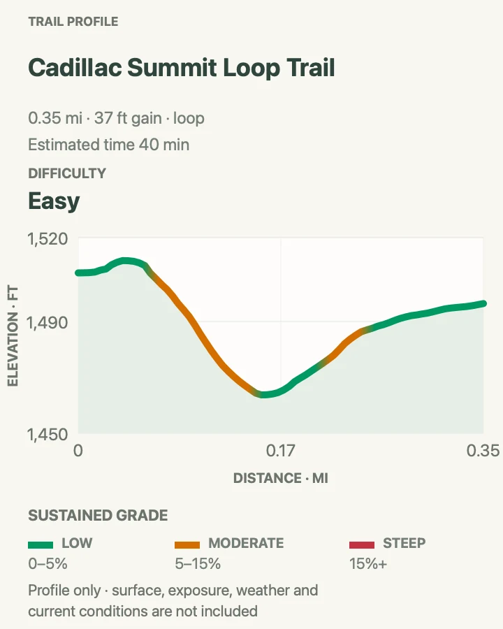
| Cadillac Summit Loop Trail | 0.4 miles | 20 to 40 minutes | Easy | A compact summit circuit with 360-degree views across Mount Desert Island and Frenchman Bay. |
| Cadillac South Ridge Trail | 7.1 miles | 2 to 4 hours | Moderate | Long, open approach to Cadillac summit |
| Cadillac North Ridge Trail | 4.4 miles | 2.5 to 4 hours | Moderate | Direct granite climb to the summit |
Cadillac Summit Loop Trail
- Distance
- 0.4 miles
- Elevation gain
- 37 feet
- Time
- 20 to 40 minutes
- Difficulty
- Easy
- Route type
- Loop
- Parking
- Two paved parking areas serve the summit. They are busy in summer and are reached by Cadillac Summit Road.
- Best time
- A clear early morning or late afternoon outside the busiest midday hours; bring extra layers in any season.
- Pets
- Leashed pets are allowed. Use a leash no longer than 6 feet.
The Cadillac Summit Loop packs an extraordinary amount of scenery into a short, mostly paved circuit. From the broad granite crown of Cadillac Mountain, the path moves between overlooks of Frenchman Bay, the Porcupine Islands, Bar Harbor, and the layered mountains and lakes of Mount Desert Island. Waysides explain the mountain landscape, while pockets of low spruce and hardy summit plants soften the exposed rock. It is an excellent choice for anyone who wants Cadillac's views without committing to a long climb from the valley.
The easy mileage should not encourage a rushed visit. Wind, fog, and temperature can change quickly at 1,530 feet, and damp granite is slick. Bring a layer even when Bar Harbor feels warm, stay on the designated path around restoration areas, and expect the summit to feel busy in summer. Sunrise is famous, but a clear early evening often provides gentler light and a more relaxed pace. On clear nights, stars appear quickly after the last color fades. The loop connects two summit parking areas, so note where you left the car before wandering among the overlooks.
Trail tip: Save the reservation QR code offline before entering the park because summit connectivity can be unreliable.

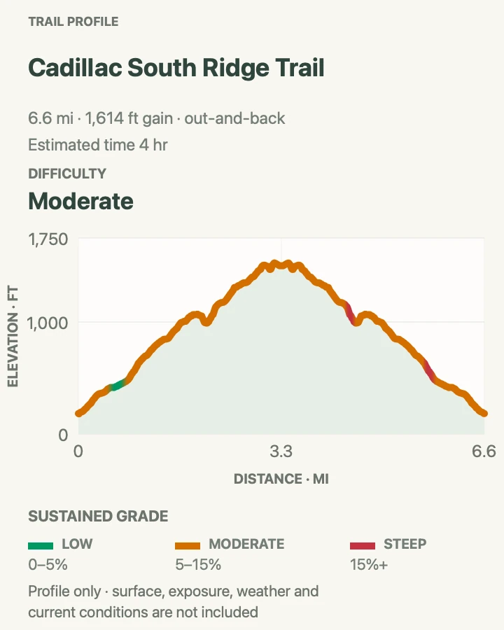
Cadillac South Ridge Trail
- Distance
- 7.1 miles
- Elevation gain
- 1,614 feet
- Time
- 2 to 4 hours
- Difficulty
- Moderate
- Route type
- Out and back
- Parking
- Limited marked shoulder parking on Route 3 just south of Blackwoods Campground
- Best time
- Early morning, with a headlamp if starting before daylight
- Pets
- Allowed on leash
South Ridge is the long, open approach to Cadillac Mountain. After a wooded beginning, the route reaches broad granite where cairns and painted blazes lead toward the summit. The grade is generally steady rather than abrupt, and the expanding view makes the climb feel like a journey across the mountain instead of a direct push to the top. Exposure to sun and wind increases as trees fall away.
The summit can feel surprisingly busy after a quiet ascent because the trail meets visitors who drove up Cadillac Summit Road. Continue to the signed summit area, then retrace the same route. Do not depend on a ride or bus from the top. There is no Island Explorer service at the summit, and vehicle access is controlled during the reservation season.
Shoulder parking near the trailhead is limited. Park fully inside a legal space and do not block the road or campground access. Sunrise hikers need a real headlamp, spare power, and warm layers. Darkness can make blazes difficult to follow on open granite, while wind at the summit may be much stronger than it was below. The climb is also rewarding later in the morning, when route finding is easier and the first rush has passed. Carry more water than the cool coastal air seems to require.

Cadillac North Ridge Trail
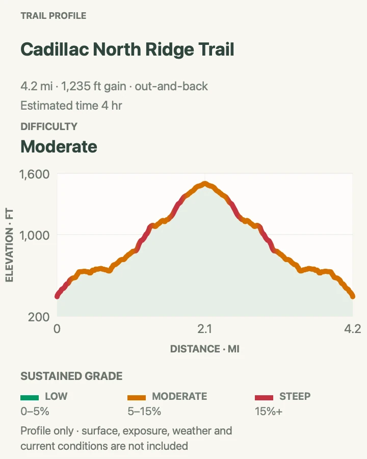
- Distance
- 4.4 miles
- Elevation gain
- 1,235 feet
- Time
- 2.5 to 4 hours
- Difficulty
- Moderate
- Route type
- Out and back
- Parking
- Tiny roadside pullout at the trailhead; Island Explorer routes 3, 4, and 5 stop at North Ridge in season
- Best time
- Early morning or late afternoon, with enough light for the descent
- Pets
- Allowed on leash
North Ridge takes the shortest practical hiking line to Cadillac’s summit. It climbs steadily through forest before spending much of its upper half on exposed granite. The route crosses Cadillac Summit Road and remains close enough to it at times to hear traffic, so it does not feel as remote as South Ridge. In return, it reaches wide views with fewer miles.
The small trailhead pullout fills quickly and is not a place to improvise a parking space. In season, Island Explorer routes 3, 4, and 5 stop at North Ridge, which avoids the pullout without adding a connector hike. Check the day’s schedule, and plan to return on foot because no bus carries hikers down from the summit.
The exposed upper trail offers little protection from sun, wind, or sudden rain. Pack layers and water, and watch for blazes where multiple worn lines cross the granite. A morning start avoids the warmest part of the climb. Late afternoon can be quieter, but the descent takes longer than a glance at the mileage may suggest. A vehicle reservation is not required to hike from the North Ridge trailhead, even during the 2026 reservation season, though a park entrance pass is still required.

Jordan Pond and the Central Mountains
This group covers the glacial lakes, carriage roads, and closely packed summits at the center of Mount Desert Island. Several routes cross large trail networks, so save an offline map and read every junction sign. Jordan Pond and the small mountain lots fill early in good weather.
| Trail | Distance | Time | Difficulty | Best for |
|---|---|---|---|---|
| Jordan Pond Path | 3.3 miles | 1 to 3 hours | Moderate | Shoreline circuit beneath the Bubbles |
| The Bubbles | 1.5 miles | 60 to 90 minutes | Moderate | Two summits and Bubble Rock |
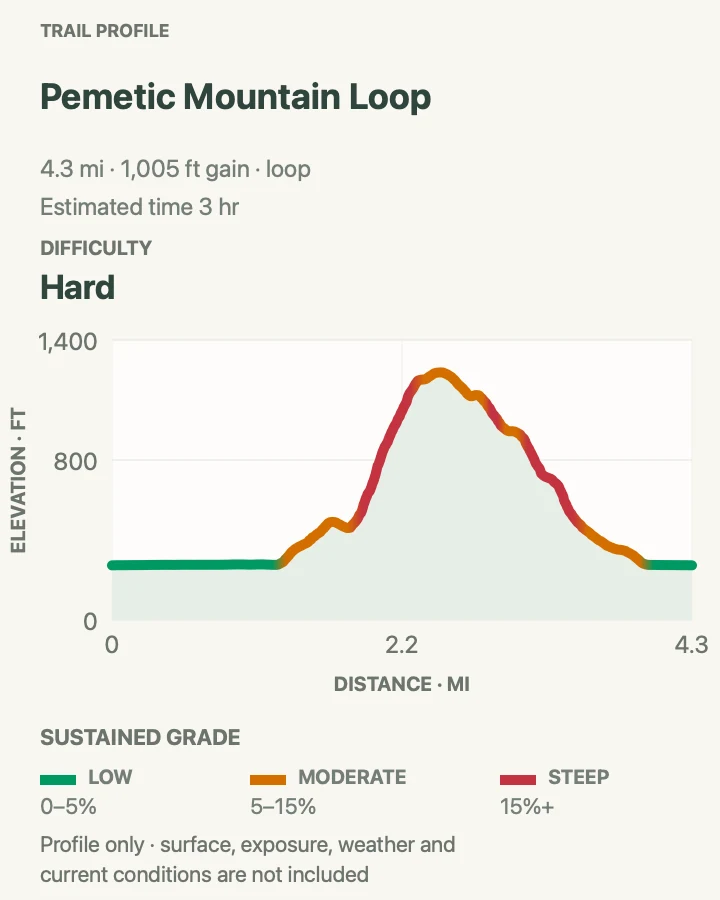
| Pemetic Mountain Loop | 4 miles | 2 to 3 hours | Hard | A rugged ladder-assisted ravine climb followed by an airy granite summit ridge. |
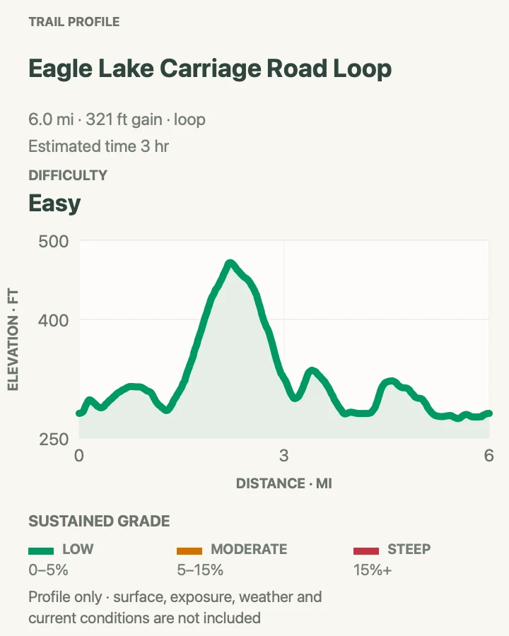
| Eagle Lake Carriage Road Loop | 6 miles | 2 to 3 hours | Easy | A complete circuit of Eagle Lake on Acadia's wide, motor-free historic carriage roads. |
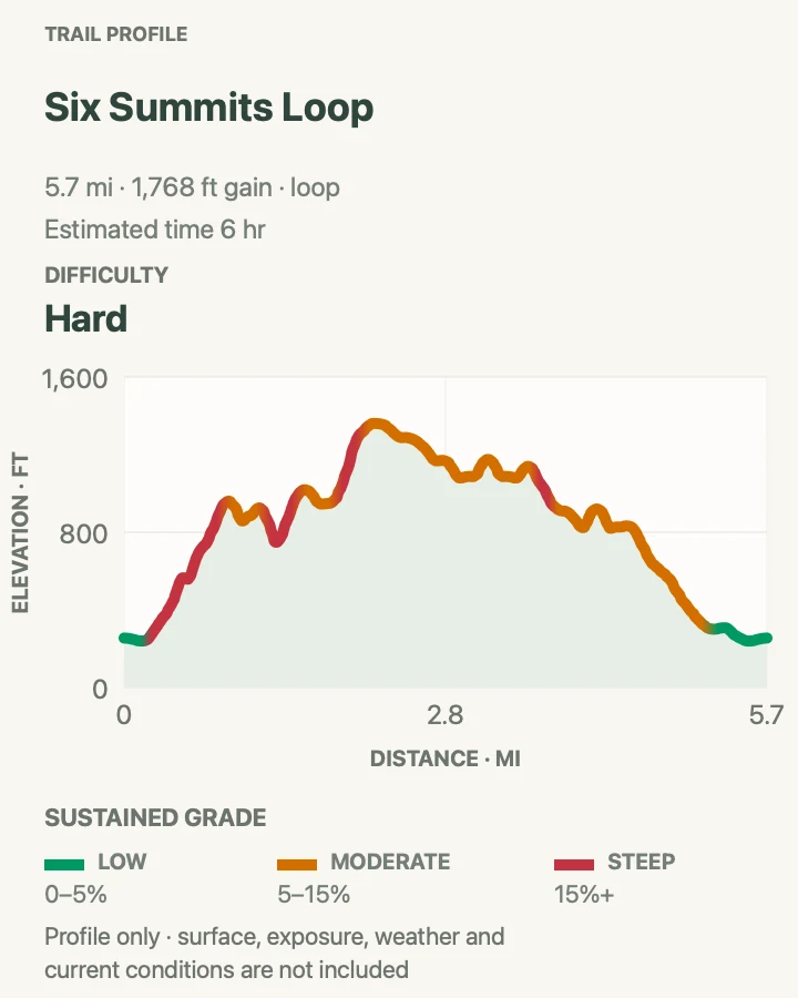
| Six Summits Loop | 5.8 miles | 4 to 6 hours | Hard | Six distinct mountain summits joined in one strenuous loop through Acadia's interior. |
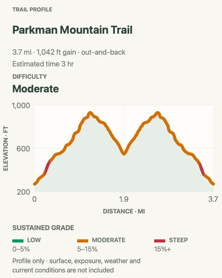
| Parkman Mountain Trail | 3.7 miles | 2 to 3 hours | Moderate | An open granite summit surrounded by the layered mountains of Acadia's interior. |
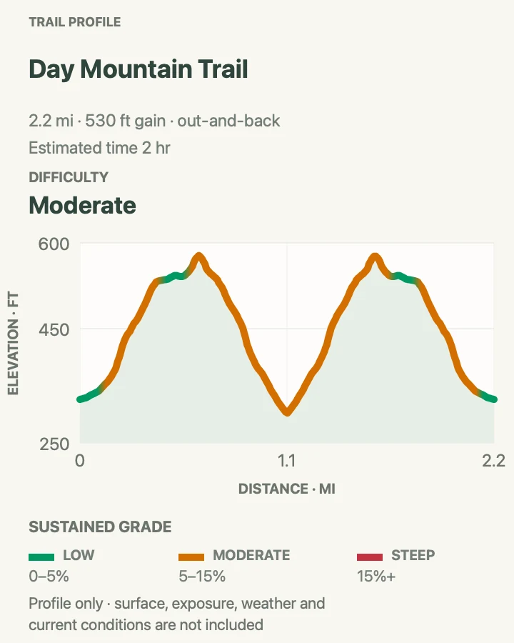
| Day Mountain Trail | 2.2 miles | 1 to 2 hours | Moderate | A quiet forest-to-granite climb with coastal views above Seal Harbor. |
Jordan Pond Path
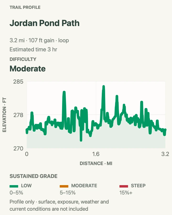
- Distance
- 3.3 miles
- Elevation gain
- 107 feet
- Time
- 1 to 3 hours
- Difficulty
- Moderate
- Route type
- Loop
- Parking
- Jordan Pond North Lot; Island Explorer route 5 serves Jordan Pond
- Best time
- Early morning or later afternoon
- Pets
- Allowed on leash; narrow bogwalk sections can be awkward for dogs
Jordan Pond Path circles one of Acadia’s clearest lakes beneath the Bubbles and Penobscot Mountain. The east shore is relatively smooth and level. The west shore is a different walk, with rough rocks, roots, and narrow raised planks that demand balance and patience. Treat the loop as a moderate trail rather than a flat waterside stroll.
Starting early improves both parking and the chance of finding quiet water near the south end. A counterclockwise loop places much of the rougher west shore earlier, while legs are fresh, though either direction works. On busy days, pass carefully on the bogwalk and avoid stepping off into soft ground. Let faster hikers use wider spots rather than forcing a squeeze on the planks.
Jordan Pond is a public water supply. Swimming and wading are prohibited, including for pets. Keep food packed near the shoreline and carry out every scrap. The open views at the north and south ends are excellent, but some of the most attractive sections sit in the quiet spruce woods along the side of the pond. Build in time for uneven footing and short pauses instead of judging the hike only by its modest elevation change.

The Bubbles
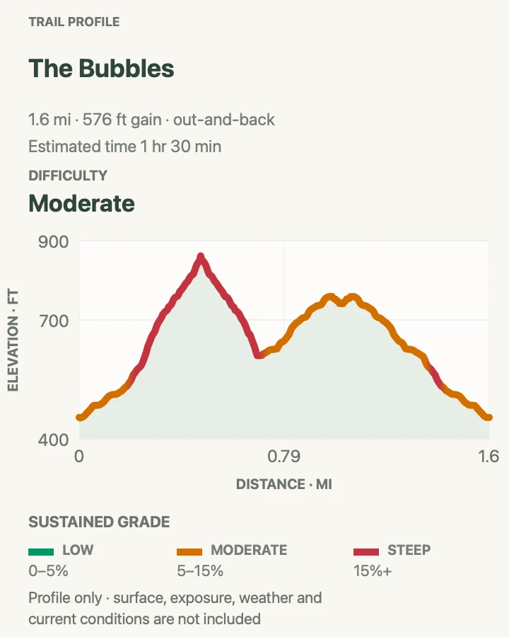
- Distance
- 1.5 miles for both summit spurs
- Elevation gain
- 576 feet
- Time
- 60 to 90 minutes
- Difficulty
- Moderate
- Route type
- Out-and-back summit spurs from Bubbles Divide
- Parking
- Small Bubbles Divide lot on Park Loop Road; Island Explorer buses do not stop at this trailhead
- Best time
- Early morning on dry rock
- Pets
- Allowed on leash, but steep rock may not suit every dog
North Bubble and South Bubble are compact granite peaks above Jordan Pond. Their short approach makes them tempting as a quick stop, but the trail is steeper and rougher than the mileage suggests. The south summit holds Bubble Rock, a large glacial boulder perched near the edge, along with the classic view down the length of Jordan Pond. North Bubble feels less theatrical and often a little quieter.
From Bubbles Divide, visit each summit as a separate spur and return to the junction between them. The direct south-side route toward Jordan Pond is much steeper than the divide approach and should not be added casually. Stay on marked rock, especially around Bubble Rock, where shortcuts damage thin soil and vegetation. The boulder is stable, but climbing or pushing on it creates needless risk near a drop.
The Bubbles lot has very little capacity, and Island Explorer buses do not stop at the trailhead. If no legal space is open, continue instead of waiting on Park Loop Road and return at another time. Morning gives the best chance of a calm summit and an open space. Bring water, shoes with traction, and bug spray for the wooded divide. After rain, wait for the granite to dry. Families should keep children close at viewpoints and choose turnaround points based on comfort, not the desire to complete both summits.

Pemetic Mountain Loop
- Distance
- 4 miles
- Elevation gain
- 1,005 feet
- Time
- 2 to 3 hours
- Difficulty
- Hard
- Route type
- Loop
- Parking
- Use the Jordan Pond parking areas and follow signs to the Jordan Pond Path trailhead. Lots often fill by late morning; the Island Explorer is a useful alternative in season.
- Best time
- A dry morning from late spring through fall, before afternoon crowds and heat build around Jordan Pond.
- Pets
- Pets are not allowed on this route because of its ladders, iron rungs, and steep sections.
Pemetic Mountain Loop starts gently beside Jordan Pond, then changes character in a hurry. The northwest approach enters a steep, boulder-strewn ravine where iron rungs and ladders help with the climb. Higher up, forest gives way to open granite and a long summit ridge with views over Jordan Pond, the Bubbles, Sargent Mountain, and the island's interior lakes. The south ridge makes a more gradual descent through exposed ledges before paths along the pond complete the circuit.
This is a compact but serious mountain hike. Dry weather matters because smooth granite, roots, and wooden sections become slippery after rain. Start early enough to clear the Jordan Pond congestion and carry more water than the distance might suggest, since much of the upper route is exposed to sun and wind. Shade is limited once the route reaches the ridge. Follow the marked loop carefully at the road and pond junctions, where several nearby paths can pull hikers in the wrong direction. If ladders or tight scrambling are not appealing, choose another Pemetic approach rather than trying to maneuver around the hardware.
Trail tip: Treat the northwest ravine as the ascent so the ladders and boulder moves are handled going up.

Eagle Lake Carriage Road Loop
- Distance
- 6 miles
- Elevation gain
- 321 feet
- Time
- 2 to 3 hours
- Difficulty
- Easy
- Route type
- Loop
- Parking
- Use the paved Eagle Lake carriage-road lot on the north side of Route 233. Accessible spaces and vault toilets are near the carriage-road entrance.
- Best time
- Early morning in summer or a crisp fall day; confirm that the carriage roads are open during spring thaw.
- Pets
- Leashed pets are allowed. Use a leash no longer than 6 feet and keep pets close around bicycles and horses.
The Eagle Lake loop is six miles of broad crushed-stone carriage road wrapped around one of Acadia's largest lakes. Its northern and eastern sides roll gently through woods with regular glimpses of open water. The western and southern sides pull farther from shore and climb to a noticeably higher point before descending again. Granite coping stones, carefully graded curves, and the Eagle Lake Bridge give the route the craftsmanship and rhythm that make the carriage-road system distinctive.
This is easy underfoot, but it is a shared route rather than a quiet footpath. Walkers, runners, cyclists, horses, and carriages may all appear, so keep right, listen for passing traffic, and keep children and dogs close. Hikers who want the most peaceful experience should begin early, especially on fair summer weekends. The full loop is long enough to merit water and a snack even though the grades are modest. Lake views are intermittent rather than continuous, which makes each opening feel earned. In fall, the open stretches along the lake are especially handsome, while spring access depends on whether the roadbed has dried enough to open.
Trail tip: Follow carriage-road intersection numbers 6, 9, 8, 7, and back to 6 to stay on the lake loop.

Six Summits Loop
- Distance
- 5.8 miles
- Elevation gain
- 1,768 feet
- Time
- 4 to 6 hours
- Difficulty
- Hard
- Route type
- Loop
- Parking
- Use the Parkman Mountain parking area on Route 198 near the Hadlock Brook and Bald Peak trail access. The Island Explorer serves the Parkman Mountain stop in season.
- Best time
- A cool, dry day with an early start and a stable forecast; avoid hot afternoons and wet granite.
- Pets
- Leashed pets are allowed, but this route is not recommended for dogs because of sustained climbing, steep granite, scrambling, and an iron-rung section.
Six Summits is a full day of constant change across Acadia's central mountains. The loop links Bald Peak, Parkman Mountain, Gilmore Peak, Sargent Mountain, Penobscot Mountain, and Cedar Swamp Mountain, moving between mossy woods, root-laced climbs, open granite, ponds, and broad ridgelines. No single ascent lasts forever, but the repeated climbing adds up, and every summit offers a different angle on the island's lakes, mountains, and distant coast. Quiet stretches between peaks can feel surprisingly remote.
The repeated climbing and rough footing make the loop tougher than the distance implies. Expect frequent roots, rock steps, and scrambly transitions that make a fast pace unrealistic. Bring a downloaded map, plenty of water, food, and a spare layer for Sargent's exposed summit. A water filter is not a substitute for carrying enough. Clockwise travel gives many hikers a more comfortable rhythm, though either direction still includes steep descents. Junctions are generally signed, but the short side trips to individual summits are easy to miss when attention fades. Check your route at every intersection rather than relying on the most obvious tread.
Trail tip: Download the route in advance and watch closely for the Penobscot Mountain turn, which is easy to walk past.

Parkman Mountain Trail
- Distance
- 3.7 miles
- Elevation gain
- 1,042 feet
- Time
- 2 to 3 hours
- Difficulty
- Moderate
- Route type
- Out and back
- Parking
- Use the Parkman Mountain parking area on Route 198. The Island Explorer serves the Parkman Mountain stop during its operating season.
- Best time
- A cool, dry morning or a clear fall day.
- Pets
- Leashed pets are allowed, but this route is not recommended for dogs because of rough, steep rock. Use a leash no longer than 6 feet.
Parkman Mountain Trail makes a satisfying interior-mountain outing, climbing from Route 198 through forest and over open granite to a compact summit. The upper ledges look across a dense gathering of Acadia peaks, with Sargent Mountain rising nearby and Eagle Lake visible through the folds of the landscape. The route's mix of wooded tread, carriage-road crossings, rock steps, and exposed ridge keeps the out-and-back engaging in both directions.
Although the trail is rated moderate, the full route is not a casual walk. Repeated roots and rocks slow the pace, and the granite can be slippery after rain. Carry water and a layer, since the summit is exposed even when the parking area feels sheltered. Clear autumn days bring especially sharp views across the interior. The small summit ledges reward a lingering break. Several trail and carriage-road junctions cluster around Parkman, so read signs carefully on the return and do not assume every downhill path leads to the same lot. Parking is limited along Route 198, but the Island Explorer stops at Parkman Mountain in season and removes the need to negotiate the busy roadside pullout.
Trail tip: Photograph the junction signs on the way up to make the return through the trail network simpler.

Day Mountain Trail
- Distance
- 2.2 miles
- Elevation gain
- 530 feet
- Time
- 1 to 2 hours
- Difficulty
- Moderate
- Route type
- Out and back
- Parking
- Use the small Day Mountain trailhead parking area off Route 3 near the Samuel de Champlain memorial plaque. Park only in designated spaces.
- Best time
- A clear, dry morning, especially during summer or fall.
- Pets
- Leashed pets are allowed. Use a leash no longer than 6 feet.
Day Mountain Trail is a steady climb from Route 3 to a rounded summit above Seal Harbor. The path rises through mixed forest, crosses the carriage road, and continues over increasingly open granite. Near the top, breaks in the trees look toward the Cranberry Islands, the Atlantic, and the mountains surrounding Jordan Pond. The summit is modest compared with Cadillac or Sargent, but the quieter setting and changing forest make the walk feel pleasantly removed from Acadia's busiest corridors.
The grade is moderate rather than severe, though roots, stone steps, and ledges still require good footing. Because the route crosses a carriage road, look both ways for bicycles and horses before continuing across. The small roadside parking area fills quickly and requires care when entering or leaving Route 3. A dry morning gives the best grip on the granite and usually the clearest coastal views. Fall foliage adds color to the lower forest. Bring a layer for the exposed upper mountain and save an offline map, since several carriage-road and trail junctions in the area can make an accidental detour surprisingly easy.
Trail tip: Pause and check signs at each carriage-road crossing so you do not drift onto the wrong route.

The West Side and Somes Sound
Western Mount Desert Island sees fewer visitors than the Ocean Drive corridor, but the trails are not necessarily easier. Granite slabs, ladders, steep descents, and small parking areas are still part of the day. The reward is a quieter mountain landscape above Long Pond, Echo Lake, and Somes Sound.
| Trail | Distance | Time | Difficulty | Best for |
|---|---|---|---|---|
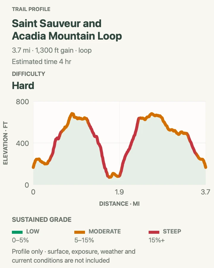
| St. Sauveur and Acadia Mountain Loop | 3.8 miles | 2 to 4 hours | Hard | Quiet west-side summits and Somes Sound views |
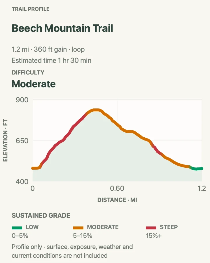
| Beech Mountain Trail | 1.2 miles | 1 to 1.5 hours | Moderate | A historic fire tower above open ledges overlooking Long Pond and the western mountains. |
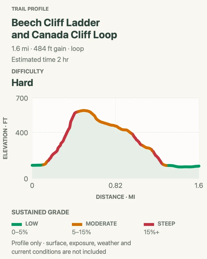
| Beech Cliff Ladder and Canada Cliff Loop | 1.7 miles | 1 to 2 hours | Hard | Four iron ladders scaling the cliff directly above Echo Lake. |
| Perpendicular and Razorback Loop | 3.2 miles | 2 to 3 hours | Hard | A hand-built ascent of more than 300 granite steps through a mossy talus slope. |
| Flying Mountain Trail | 1.5 miles | 1 to 1.5 hours | Moderate | A low summit with expansive views along the glacial channel of Somes Sound. |
St. Sauveur and Acadia Mountain Loop
- Distance
- About 3.8 miles
- Elevation gain
- 1,300 feet
- Time
- 2 to 4 hours
- Difficulty
- Hard
- Route type
- Loop using St. Sauveur Mountain, Acadia Mountain, and Valley Peak trails
- Parking
- Acadia Mountain trailhead lot on Route 102; Island Explorer service is available in season
- Best time
- Morning, especially in warm weather
- Pets
- Allowed on leash, but steep loose descents may be difficult for dogs
This west-side circuit links St. Sauveur Mountain with Acadia Mountain for a rugged tour above Somes Sound. The summits are lower than Cadillac, but the route repeatedly climbs and drops over roots, loose stone, and steep granite. Views open toward the sound, Echo Lake, and the mountains surrounding the island’s quieter western half.
Good footing matters most on the descents. Slow down on loose rock and give hikers below enough space that a dislodged stone cannot reach them. Carry enough water for the whole loop because there is no reliable treated water on the route. Morning shade makes the wooded climbing more comfortable, and an early arrival helps with the small Route 102 parking area.
Keep the loop to the signed St. Sauveur Mountain, Acadia Mountain, and Valley Peak trail connections. If nearby Valley Cove Trail appears in the current conditions panel as closed, do not enter the signed closure. Trail junctions on this side of the park create several possible variations, so download the route and read each sign instead of following the group ahead. If rain makes the granite slick, choose a lower trail or turn back before committing to the steepest descent.

Beech Mountain Trail
- Distance
- 1.2 miles
- Elevation gain
- 360 feet
- Time
- 1 to 1.5 hours
- Difficulty
- Moderate
- Route type
- Loop
- Parking
- Drive to the Beech Mountain parking lot at the end of Beech Hill Road. The trail starts on the northwest side of the lot near the restrooms; no Island Explorer service reaches this trailhead.
- Best time
- Early morning or sunset in dry weather, with a headlamp for any outing that may finish after dusk.
- Pets
- Leashed pets are allowed, but dogs are not allowed on the fire tower.
Beech Mountain Trail packs a surprising amount of variety into 1.2 miles. The loop begins in forest, climbs over roots and granite steps, then breaks onto open slabs with views across Long Pond toward Mansell Mountain. Near the summit stands one of the area's remaining fire towers, an unmistakable landmark above the western side of Mount Desert Island. Several ledges below the top make fine places to pause, and their open views can be better for lingering than the small summit area.
Hiking the loop clockwise puts the steeper, rockier branch on the climb and leaves the more gradual side for the descent. That choice is particularly helpful when the granite is damp, though good-traction shoes are useful in either direction. Sunset is lovely here, but the wooded return becomes dark quickly, so carry a headlamp and an extra layer. The trailhead lot is not large and there is no bus service, making an early start wise. Do not count on the short distance to make a full parking lot turn over quickly, since many people stay for the views.
Trail tip: Go clockwise so the steeper branch is climbed rather than descended.

Beech Cliff Ladder and Canada Cliff Loop
- Distance
- 1.7 miles
- Elevation gain
- 484 feet
- Time
- 1 to 2 hours
- Difficulty
- Hard
- Route type
- Loop
- Parking
- Use the Echo Lake parking area on Route 102. The lot also serves the beach, fills on hot days, and does not allow RVs or trailers. Seasonal Island Explorer service is available.
- Best time
- A dry morning before the beach crowd arrives; avoid rain, fog, and strong wind.
- Pets
- Pets are prohibited on Beech Cliff Trail.
Beech Cliff rises sharply above Echo Lake, and this loop reaches its ledges by the most adventurous line. Stone stairs lead into a steep boulder field before four iron ladders climb the cliff in quick succession. Above them, exposed granite overlooks the beach, Somes Sound, and a sweep of western Mount Desert Island. Canada Cliff Trail provides the calmer half of the circuit, descending gradually through forest and returning to the lake.
Travel counterclockwise so the ladders are climbed, not descended against uphill traffic. The route is short but strenuous, with real exposure and places where both hands are useful. It is a poor choice for anyone uneasy with heights, small children who cannot follow safety directions, or wet weather. The Echo Lake lot serves swimmers as well as hikers and can fill on warm summer days. An early start or the seasonal Island Explorer avoids the worst parking pressure. Gloves are optional, but dry hands help on the iron. Keep three points of contact on the ladders, wait for the person above to clear each section, and stay well back from cliff edges at the overlooks.
Trail tip: Hike counterclockwise, ascending Beech Cliff and returning on Canada Cliff Trail.

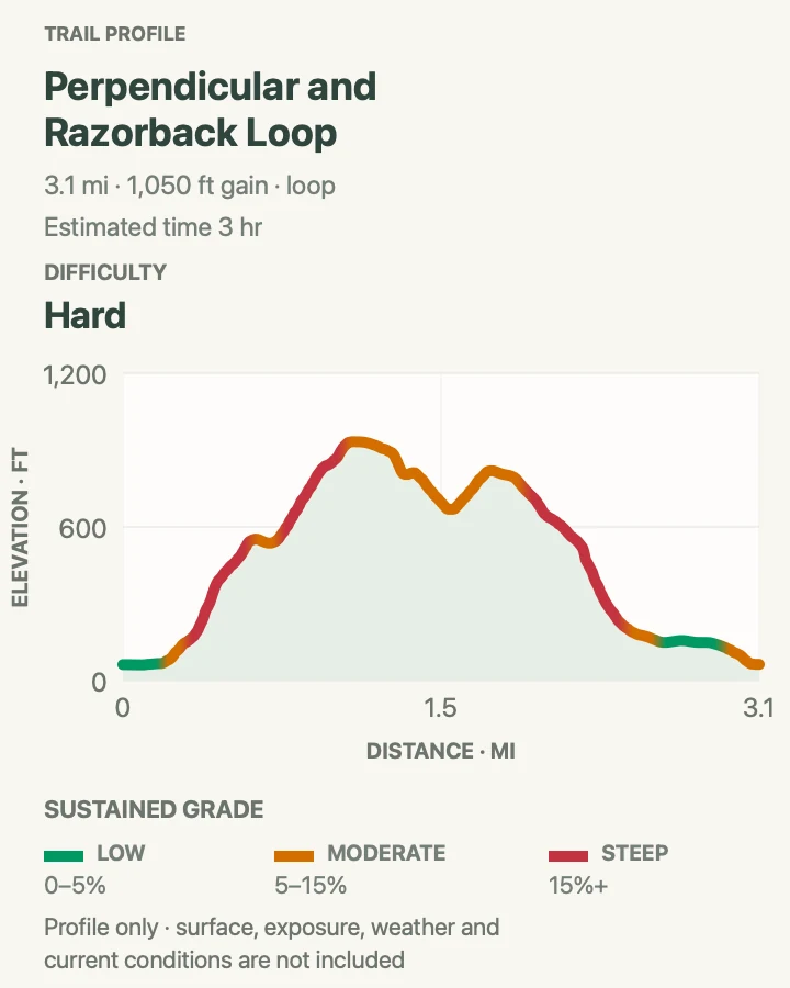
Perpendicular and Razorback Loop
- Distance
- 3.2 miles
- Elevation gain
- 1,050 feet
- Time
- 2 to 3 hours
- Difficulty
- Hard
- Route type
- Loop
- Parking
- Park at the south end of Long Pond, reached from Seal Cove Road and Long Pond Road. The Long Pond Trail begins beyond the municipal water pumping station.
- Best time
- A cool, dry morning from late spring through fall.
- Pets
- Pets are prohibited on Perpendicular Trail.
Perpendicular Trail is one of Acadia's most remarkable pieces of trail construction. More than 300 cut granite steps climb Mansell Mountain through a wooded talus slope, with flat stones fitted into the hillside by Civilian Conservation Corps crews. A few iron rungs and a small ladder assist the steepest moves. The summit itself is wooded, but a short spur below it opens a satisfying view over Long Pond, Beech Mountain, and the outer islands. Razorback Trail supplies a rough, scenic descent along the ridge.
The forested setting can make this route look gentler than it is. Stairs, roots, loose rock, and the ladder demand deliberate footing, especially on the descent. Climb Perpendicular and descend Razorback so the most engineered and awkward section is handled uphill. Allow more time than the mileage alone suggests, and avoid the route when rain has slickened the stone. Trekking poles help on Razorback. Long Pond is a municipal water supply, so respect signs and stay on the established route near the shore. There is no bus to this trailhead, and the quiet south-end lot has no accessible restroom.
Trail tip: Climb Perpendicular first and save Razorback for the descent.

Flying Mountain Trail
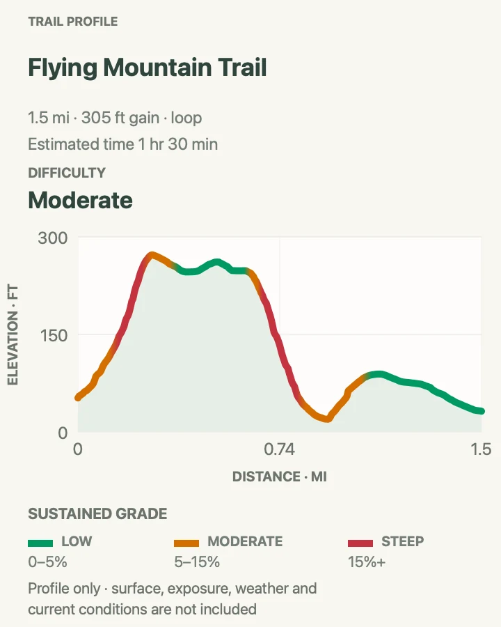
- Distance
- 1.5 miles
- Elevation gain
- 305 feet
- Time
- 1 to 1.5 hours
- Difficulty
- Moderate
- Route type
- Loop
- Parking
- Use the small Flying Mountain parking area at the end of Fernald Point Road. Arrive early and park only in designated spaces.
- Best time
- A dry morning or late afternoon after the complete loop has reopened.
- Pets
- Leashed pets are allowed when the complete route is open, but this hike is not recommended for dogs because of steep ledges and rough footing.
Flying Mountain delivers classic Somes Sound scenery from one of Acadia's lower summits. The trail climbs almost immediately over roots, stone steps, and a short steep ledge, then reaches open viewpoints above Southwest Harbor and Northeast Harbor. Beyond the 284-foot summit, the path drops through spruce woods toward Valley Cove, a secluded cobble beach beneath the western cliffs of the sound. The changing terrain makes the hike feel much bigger than its modest elevation.
Under normal access, hikers complete the loop by returning from the cove on the broad Valley Cove Trail. When Valley Cove Trail appears in the current conditions panel as closed, the mapped loop is closed and must not be followed. Do not improvise an alternate route around posted closure boundaries. Wait until the complete route reopens, then expect a steep descent from the summit that can be slick when wet. Parking is limited at the end of Fernald Point Road, and the trail is not served by the Island Explorer.
Trail tip: Treat the complete loop as closed whenever Valley Cove Trail is listed as closed, and do not substitute an unverified route.

Seawall and the Southwest Coast
The southwest coast offers two easy walks through spruce woods to rocky Atlantic shore. Both trailheads have small lots and no Island Explorer service. Arrive early, bring insect repellent in summer, and time a visit near low tide if tide pools are part of the plan.
| Trail | Distance | Time | Difficulty | Best for |
|---|---|---|---|---|
| Ship Harbor Trail | 1.5 miles | 45 to 75 minutes | Easy | A figure-eight walk that pairs a sheltered tidal harbor with open granite coastline. |
| Wonderland Trail | 1.3 miles | 45 to 75 minutes | Easy | An easy old fire road ending at family-friendly tide pools on a quiet stretch of coast. |
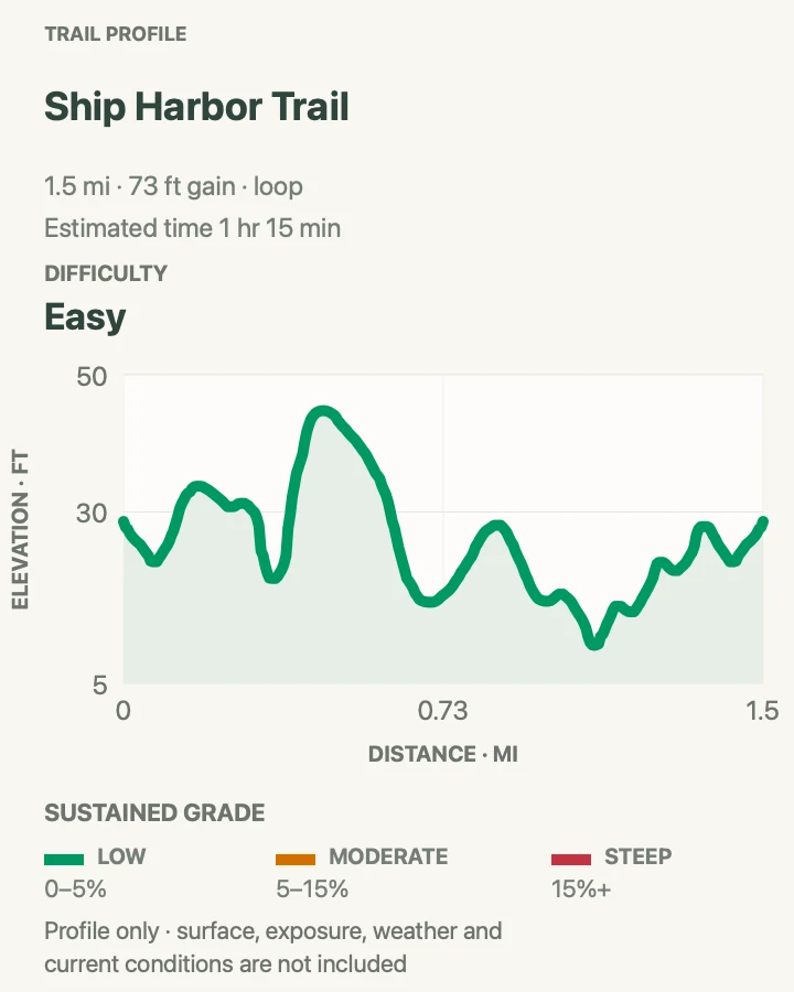
Ship Harbor Trail
- Distance
- 1.5 miles
- Elevation gain
- 73 feet
- Time
- 45 to 75 minutes
- Difficulty
- Easy
- Route type
- Figure eight loop
- Parking
- A small lot and designated parallel spaces sit along Route 102A. Accessible spaces and a vault toilet are at the trailhead; display a valid park pass.
- Best time
- Early morning near low tide for easier parking, active birdlife, and exposed tide pools.
- Pets
- Leashed pets are allowed. Use a leash no longer than 6 feet.
Ship Harbor Trail traces a compact figure eight through spruce and pitch pine to a narrow tidal inlet and the open Atlantic shore. The first loop is broad and mostly packed gravel, with views into the harbor and good opportunities for birding. The second loop becomes more traditional Acadia trail, crossing roots, rocks, and stairs before reaching granite ledges and tide pools. It is an easy family outing with enough variety to keep a short walk interesting.
Low tide reveals the most shoreline detail, but the coastal ledges are rewarding in any clear weather. Never turn your back on the ocean, and keep children away from wet edges where waves can surprise them. In summer the woods can be buggy, so repellent makes the inland half much more pleasant. The small lot often fills by late morning, though legal parallel spaces are available along the road near the trailhead. Plan a few quiet minutes on the rocks for the full reward. People using strollers or mobility devices may prefer the first 0.8-mile loop, since the outer section adds stairs and rougher footing.
Trail tip: Bring insect repellent in summer and leave time to explore the shore rather than rushing the loop.

Wonderland Trail
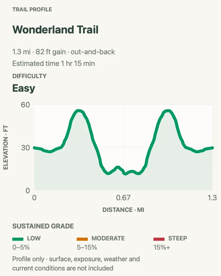
- Distance
- 1.3 miles
- Elevation gain
- 82 feet
- Time
- 45 to 75 minutes
- Difficulty
- Easy
- Route type
- Out and back
- Parking
- Use the small Wonderland lot on the east side of Route 102A, about 3.1 miles beyond the Route 102 junction. There is no Island Explorer service.
- Best time
- Early morning around a falling low tide, especially in summer when parking and mosquitoes become more troublesome later.
- Pets
- Leashed pets are allowed, but dogs are not recommended around the tide pools. Use a leash no longer than 6 feet.
Wonderland is a gentle walk through spruce forest to the ragged shore of Bennett Cove. The old gravel fire road stays nearly level, passing patches of jack pine before opening onto granite, cobbles, and small intertidal pools. On a clear day the view reaches toward the Duck Islands and Great Cranberry Island. The easy grade and broad path make this a welcome recovery outing between Acadia's mountain hikes, while the shoreline gives children plenty to investigate.
Time the walk for a falling tide if tide pools are the goal, and begin exploring before low tide rather than following the water outward as it rises. Roots and stones still cross the path, so it is not quite a sidewalk, and the final rocks can be slick. Mosquitoes often gather in the shaded woods during warm, still weather; repellent is worth carrying even on this short route. Parking is limited and there is no bus service, making an early arrival useful. Bring a small hand lens for closer tide-pool viewing. Once at the coast, stay alert to waves and handle any tide-pool creatures gently without removing them.
Trail tip: Pack insect repellent and shoes with grip for wet shoreline rocks.

Schoodic Peninsula
Schoodic Peninsula feels quieter and more open than the main part of Acadia. These two trails pair forest, granite, and coastal views without long mileage. Roadside parking is prohibited, so use designated spaces and allow time for the peninsula's one-way road.
| Trail | Distance | Time | Difficulty | Best for |
|---|---|---|---|---|
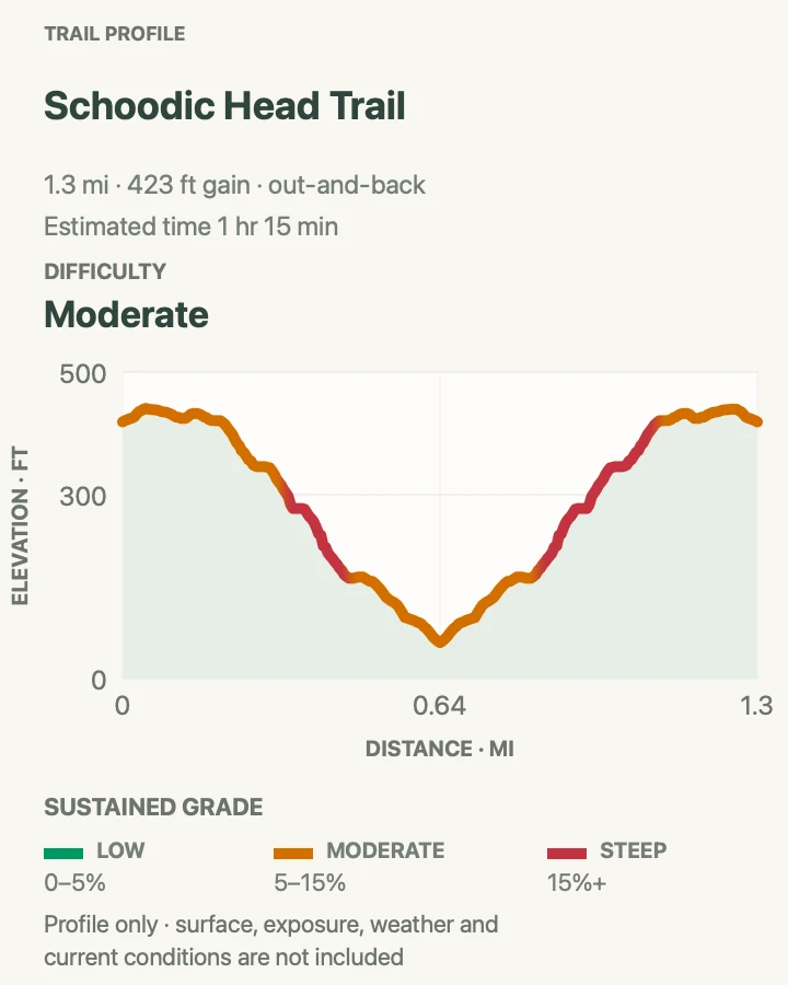
| Schoodic Head Trail | 1.2 miles | 45 to 75 minutes | Moderate | A rocky summit-top trail with a distant look back toward Mount Desert Island. |
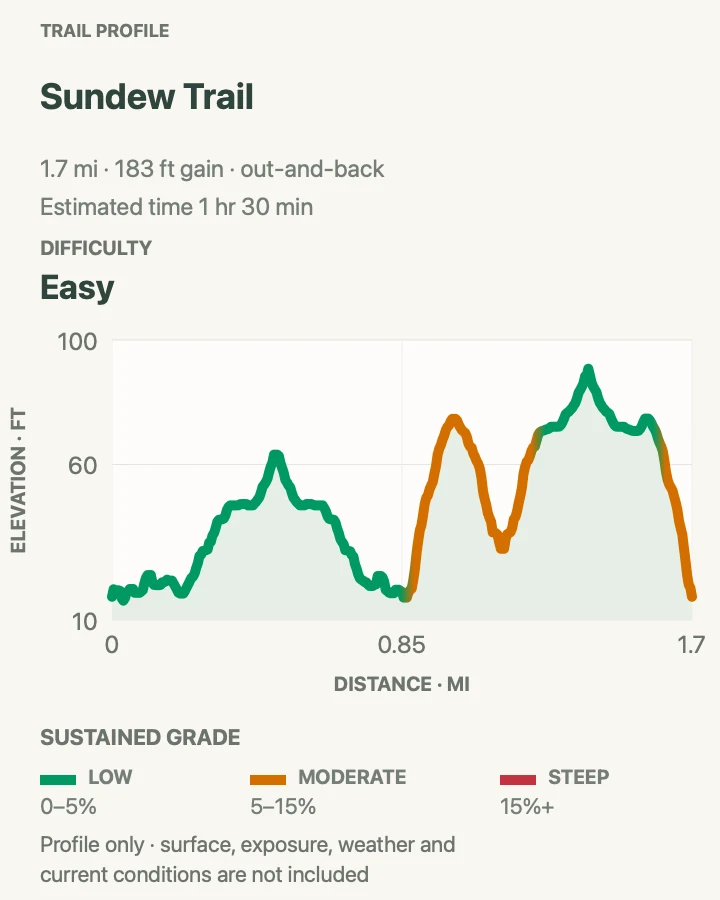
| Sundew Trail | 1.7 miles | 45 to 90 minutes | Easy | A quiet forest nature trail with several spurs to cobble beaches and tide pools. |
Schoodic Head Trail
- Distance
- 1.2 miles
- Elevation gain
- 423 feet
- Time
- 45 to 75 minutes
- Difficulty
- Moderate
- Route type
- Out and back
- Parking
- Park only in the small designated area at the end of Schoodic Head Road. Roadside parking is prohibited throughout the Schoodic District.
- Best time
- A clear, dry morning when coastal fog has lifted and the granite is not wet.
- Pets
- Leashed pets are allowed. Use a leash no longer than 6 feet.
Schoodic Head Trail crosses the rocky crown of the peninsula's highest hill, offering a perspective that feels distinct from Mount Desert Island. Spruce and pitch pine crowd close to the path, then part at granite openings with views over the Schoodic landscape and across the water toward Acadia's taller mountains. The route is short, but roots, rocks, and uneven ledges give it the texture of a real summit hike rather than a roadside stroll.
This out-and-back starts from the small parking area at the end of Schoodic Head Road and follows the same trail both ways. Move carefully on damp rock, which stays slick under the trees long after a shower. Fog is common on the peninsula and can erase the distant views, though the woods remain atmospheric. A clear morning offers the best combination of cooler temperatures and visibility. Blueberries may edge sunny openings later in summer. Watch for birds. Schoodic is quieter than the main part of Acadia, but parking at the summit is limited, so do not block the road or create a space outside the designated area.
Trail tip: Pair the hike with Blueberry Hill or Schoodic Point, but allow extra driving time on the peninsula's one-way road.

Sundew Trail
- Distance
- 1.7 miles
- Elevation gain
- 183 feet
- Time
- 45 to 90 minutes
- Difficulty
- Easy
- Route type
- Out and back with shoreline spurs
- Parking
- Use designated visitor parking on the Schoodic Institute campus near Eliot Hall, then follow campus signs to the trail. Roadside parking is prohibited in the Schoodic District.
- Best time
- Morning around a falling low tide, or during a ranger-led walk when one is scheduled.
- Pets
- Leashed pets are allowed. Use a leash no longer than 6 feet.
Sundew Trail wanders through the forest and shoreline of the Schoodic Education and Research Center campus. Ferns, spruce, pine, moss, and exposed roots create a cool green corridor, while short side paths reach cobble beaches and quiet views across the water. The route is nearly level and rewards a slow pace, especially for people interested in plants, geology, birds, and the small details of the intertidal zone. Ranger walks sometimes add welcome context to this subtle landscape.
The mapped outing includes shoreline spurs, so distance depends on how many coves and overlooks you explore. Low tide reveals the most at Cobble Beach, with the best window beginning before low tide and ending as the water starts to return. Wear shoes that can handle roots and wet stones, and never turn your back on the ocean. Pause often. The trail can be surprisingly easy to miss among campus roads and buildings; park near Eliot Hall and confirm the start before wandering onto an administrative drive. Because Schoodic receives fewer visitors, carrying an offline map is useful even on this gentle route.
Trail tip: Allow extra time for the shoreline spurs and save an offline map before entering the campus.

Build a day that fits the conditions
A satisfying Acadia day does not require collecting several summits. Match one main hike to the weather, then keep a lower, less exposed option in reserve. Ocean Path works well when clouds obscure the mountains. Jordan Pond Path is a sensible alternative when high wind makes open ridges unpleasant, though its rocks and planks still become slick in rain. On a dry, calm day, a ladder route can be the focus rather than an add-on between other stops.
Parking, shuttle timing, wet granite, and wildlife closures can change the plan after arrival. Leave enough space in the schedule to adjust without rushing. The park is compact, but its trails reward patience: slower feet find the blazes, notice the changing coast, and arrive back at the trailhead with daylight to spare.