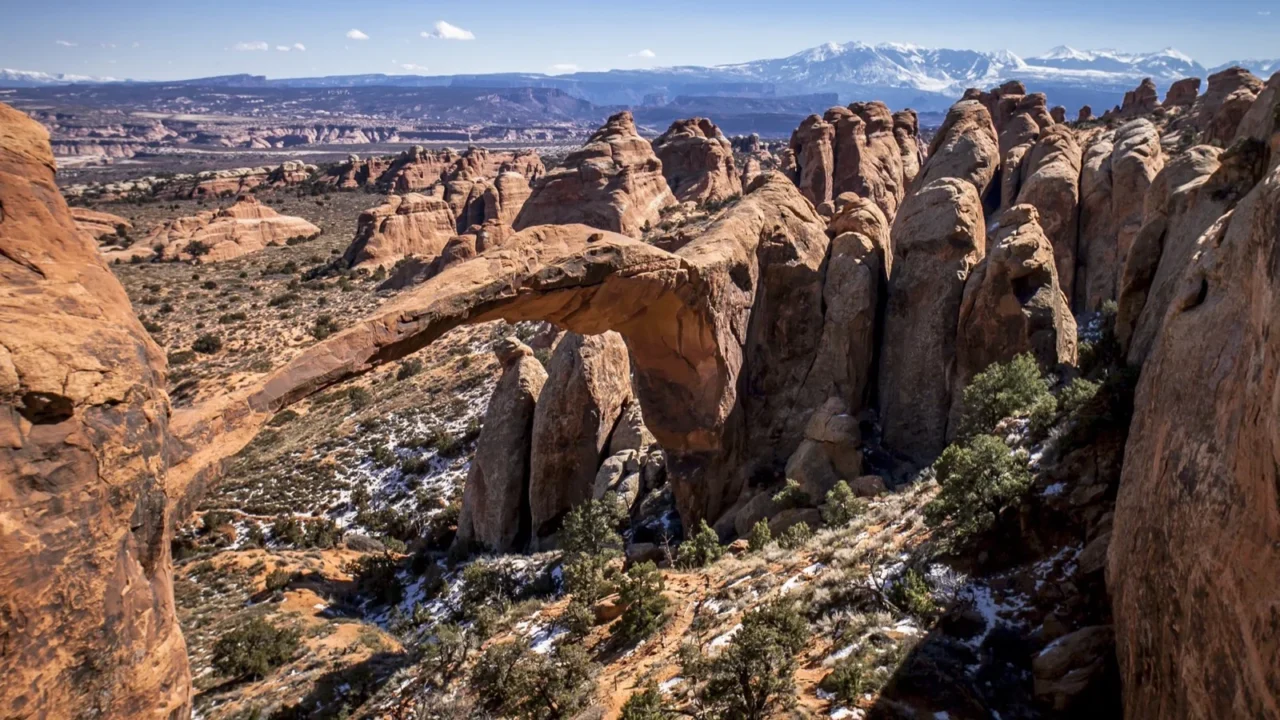
Arches is famous for viewpoints that can be seen from a car, but the park makes much more sense on foot. A trail can leave the road for only a few hundred yards and enter a chamber of red sand, climb beneath a span wider than a football field, or cross a sandstone fin high above the desert. These 25 routes cover everything from a nearly level visitor center walk to the exposed sandstone fins of Devils Garden.
Short interpretive paths, accessible viewpoints, family walks, exposed slickrock climbs, permit-only exploration, and remote desert routes all appear here. Several share a parking area or a section of tread, then branch into noticeably different outings. Windows Primitive Loop is rougher than the main Windows path. Broken Arch Loop adds a campground connector and scrambling to the easy out-and-back. Devils Garden spurs create clear turnaround choices before the full primitive circuit.
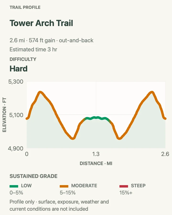
Treat every distance as a planning estimate. Park signs round some totals, and short spur routes can vary with the exact turnaround point. The elevation gain beside each hike comes from the same line shown on its profile. Heat, deep sand, exposed rock, and route-finding often matter more than a tenth of a mile.
For entrance logistics, scenic stops, camping, and a broader park overview, start with the Arches National Park visitor guide.
Plan before driving past the visitor center
Carry a primary plan and a shorter backup. A full lot, rising heat, lightning, wet slickrock, or an impassable dirt road can make the original choice wrong for the day. The park has enough variety to change course without forcing a risky start.
Entrance reservations and hiking permits
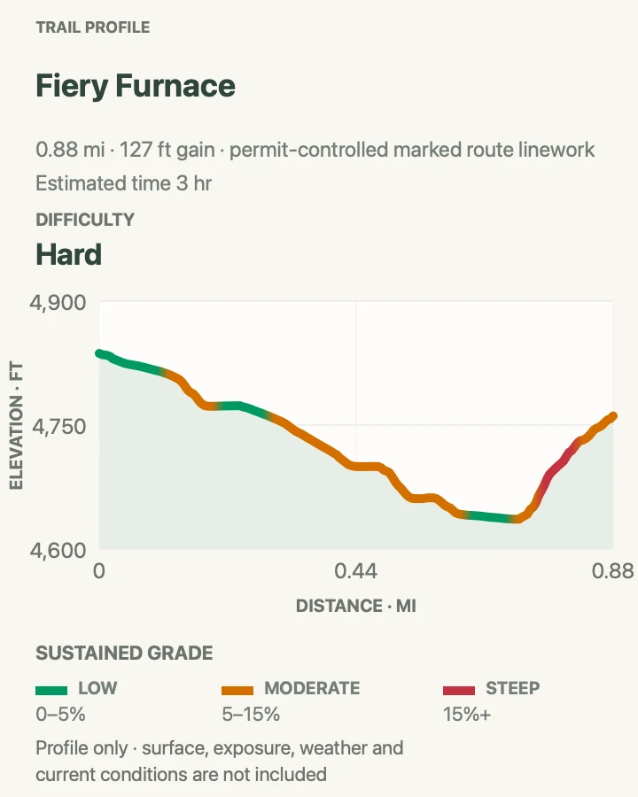
No timed-entry reservation is required to enter Arches in 2026, but the normal entrance fee or pass still applies. Heavy traffic can produce long lines, and the gate may temporarily delay vehicles when the park is too congested. Ordinary day hikes do not require trail permits. Fiery Furnace is the important exception. Entering that area requires either a reserved ranger-led hike or a self-guided exploration permit. Campground, canyoneering, commercial, and special-use reservations follow separate rules and do not substitute for Fiery Furnace authorization.
Heat, water, and the desert sun
Summer daytime temperatures can exceed 100 degrees, and most trails have little shade. The park advises avoiding exertion during peak heat and planning on roughly one gallon of water per person over a full day. Water is available at the visitor center and seasonally at Devils Garden, but not at The Windows, Wolfe Ranch, Fiery Furnace Viewpoint, or Tower Arch. Carry salty snacks, sun protection, and more water than the mileage alone seems to require. Deep sand and exposed slickrock make a short route consume more time and energy than a forest trail of the same length.
Parking without damaging the park
Delicate Arch, Devils Garden, The Windows, and other popular lots can remain full for hours. Arrive early, visit later in the day, or move to the backup trail. Never park on vegetation, biological soil crust, a road shoulder that is not signed for parking, or a lane needed by emergency vehicles. Oversize spaces are especially limited. At The Windows, walk between the connected upper and lower lots rather than driving from one to the other. At Park Avenue, return on the trail or arrange a legal two-vehicle shuttle instead of walking along the park road.
Slickrock, cairns, and route-finding
Cairns mark many routes across bare sandstone. Follow existing cairns, but do not build new ones or cut between them. An improvised stack can mislead another hiker, and a shortcut can crush living soil crust that takes years to recover. Download the map before leaving because cell service is unreliable. Wet or icy sandstone changes the difficulty immediately. Delicate Arch, the trail beyond Landscape Arch, the Windows primitive return, and Tower Arch all deserve extra caution when traction is poor. The Devils Garden primitive section should not be attempted on wet or icy rock.
Lightning, flash floods, and dirt roads
Thunderstorms create two different hazards. Lightning threatens hikers on open fins and broad slickrock, while runoff can pour through narrow passages and washes. Turn around before a storm reaches the route. Rain also changes the unpaved roads to Klondike Bluffs and the backcountry. Salt Valley Road is generally manageable by a two-wheel-drive vehicle only in normal conditions. A storm can leave deep mud, washed crossings, or a surface that requires high-clearance four-wheel drive. The safest road decision is often made at the visitor center, not after several miles of rough driving.
Pets, service animals, and arch protection
Pets are not allowed on any park hiking trail or overlook, even in a carrier. Leashed pets are limited to established roads, parking areas, campgrounds, and picnic areas. Trained service animals are allowed, but owners should evaluate heat, sharp rock, ledges, and scrambling honestly. Climbing, standing, or walking on an arch is prohibited throughout the park. That rule includes small openings as well as landmarks such as Delicate Arch and Landscape Arch. Enjoy the view from durable trail surfaces and keep hands, feet, and equipment off the spans.
How to read the maps and profiles
Each terrain map shows the route used for its elevation profile. Named arches on or immediately beside that route are labeled so a cluster such as Devils Garden remains understandable on a phone screen. The warm red, orange, and tan terrain reflects the Entrada sandstone and desert flats of Arches. Mileage derived from the route may be slightly more precise than the rounded number used by the park. Fiery Furnace is different. Its path varies by permit and exploration, so its map is an orientation aid, not turn-by-turn navigation through the maze.
Entrance and Courthouse Towers
The first miles of the park road hold four very different walks. One introduces desert plants, one protects a remarkable cultural site, one enters a canyon of monoliths, and one circles the park’s most famous balanced rock. These are useful first-day choices because they begin near the entrance and do not require a long drive. Park Avenue is the only sustained hike in the group, but even the short trails are better in cool hours.
| Trail | Distance | Time | Difficulty | Best for |
|---|---|---|---|---|
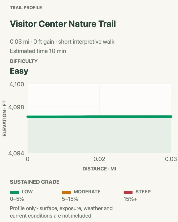
| Arches Visitor Center Nature Trail | 150 feet round trip | 10 minutes | Easy | A first walk and desert plant introduction |
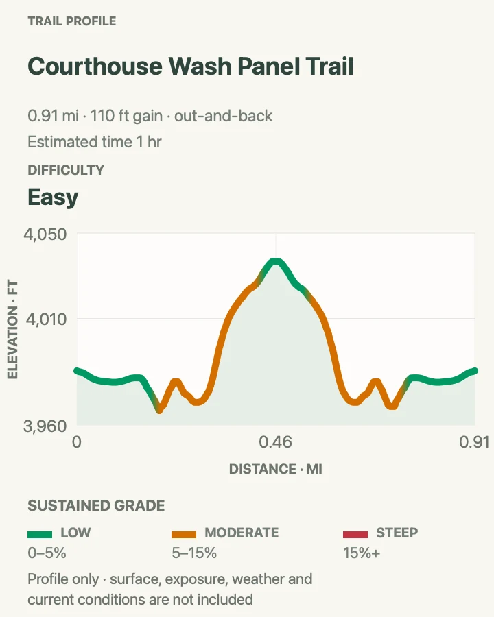
| Courthouse Wash Panel Trail | 0.8 mile round trip | 30 to 60 minutes | Easy | Rock markings and cultural history |
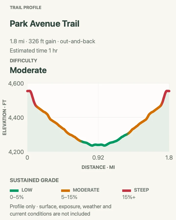
| Park Avenue Trail | 1.8 miles round trip | About 1 hour | Moderate | Walking among the Courthouse Towers |
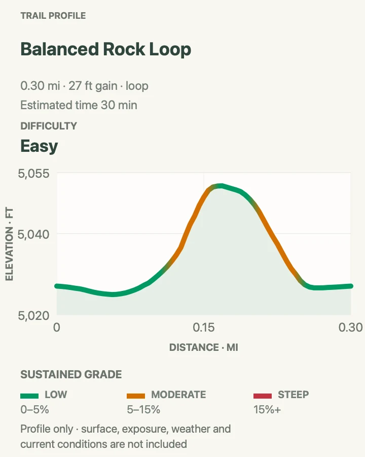
| Balanced Rock Loop | 0.3 mile | 15 to 30 minutes | Easy | Sunset and a very short loop |
Arches Visitor Center Nature Trail
- Distance
- 150 feet round trip
- Elevation gain
- Minimal; orientation profile is approximate
- Time
- 10 minutes
- Difficulty
- Easy
- Route type
- Short interpretive path
- Parking
- Use the main Arches Visitor Center parking lot. The path begins behind the visitor center.
- Best time
- During visitor center hours if you want to pair the walk with exhibits and trip-planning help. Morning and evening are cooler.
- Pets
- Pets are not allowed. Trained service animals are allowed.
This tiny nature trail is easy to overlook, but it is a useful introduction to the plants that make life possible in the high desert. Signs identify native species and explain traditional uses while the path slips behind the busy visitor center. It works well for families, travelers adjusting to the heat, and anyone who wants a short walk before committing to a longer route.
The trail is nearly level and takes only a few minutes. That makes it a practical choice when the entrance line has consumed part of the day or when wind and heat rule out exposed slickrock. Pair it with the visitor center film, refill water before leaving, and use the stop to check current road and trail conditions. The map and profile are orientation aids for the immediate visitor center plaza; follow the signed nature path on site.
Practical tips
- Fill every water container before driving into the park.
- Ask about unpaved-road conditions if Tower Arch is part of the day.
Terrain and access: Mostly level, with paving stone, cement, and dirt surfaces.

Courthouse Wash Panel Trail
- Distance
- 0.8 mile round trip
- Elevation gain
- 110 feet
- Time
- 30 to 60 minutes
- Difficulty
- Easy
- Route type
- Out and back
- Parking
- Use the signed parking area on US 191, about 0.5 mile north of the Colorado River.
- Best time
- Morning or late afternoon, when the short exposed approach is cooler.
- Pets
- Pets are not allowed. Trained service animals are allowed.
Courthouse Wash offers a different kind of stop from the park’s better-known arch trails. The route crosses the wash and climbs toward a large panel of pictographs and petroglyphs created by Indigenous travelers over a long span of time. The markings can appear faint at first, so slow down and let your eyes adjust rather than moving closer to the wall.
The first part of the path is paved, and the panel can be seen from that lower section. Reaching its base requires a brief climb on uneven rock. Bring binoculars for a better view without touching the wall. Oils from a hand can damage ancient pigment, and every artifact should remain exactly where it is found.
Practical tips
- Bring binoculars to study the panel from a respectful distance.
- Do not touch rock markings or stand on cultural features.
Terrain and access: The first section is paved and level. The final approach crosses dirt and uneven rock.

Park Avenue Trail
- Distance
- 1.8 miles round trip
- Elevation gain
- 330 feet
- Time
- About 1 hour
- Difficulty
- Moderate
- Route type
- Out and back, with a two-vehicle one-way option
- Parking
- Use Park Avenue Viewpoint or Courthouse Towers Viewpoint. Both ends have designated parking.
- Best time
- Early morning or late afternoon for cooler temperatures and stronger side light on the monoliths.
- Pets
- Pets are not allowed. Trained service animals are allowed.
Park Avenue drops into a broad sandstone corridor framed by walls and towers that resemble a city skyline. From the south overlook, stone steps descend to the canyon floor before the route rolls north toward Courthouse Towers. Starting at the north end avoids the initial staircase if you only want a gentler walk along the lower canyon, although a complete round trip still includes the climb.
The trail is exposed and can feel much hotter than the parking area. Early and late light adds depth to the Three Gossips, The Organ, Sheep Rock, and Tower of Babel. Park Avenue Arch is visible high in the wall near the south end, while tiny Baby Arch appears near Sheep Rock. Do not return along the road. Retrace the trail or arrange a legal two-vehicle shuttle.
Practical tips
- Photograph the formations from both directions because the shapes change dramatically.
- For an easier partial walk, start at Courthouse Towers and turn around before the south stairs.
Terrain and access: The overlook is accessible. The hiking trail has stairs, sand, ledges, and uneven bedrock.

Balanced Rock Loop
- Distance
- 0.3 mile
- Elevation gain
- 25 feet
- Time
- 15 to 30 minutes
- Difficulty
- Easy
- Route type
- Loop
- Parking
- Use the limited parking at Balanced Rock, 9.2 miles from the visitor center.
- Best time
- Sunset for glowing red-orange rock, or after dark for stargazing.
- Pets
- Pets are not allowed. Trained service animals are allowed.
Balanced Rock is visible from the road, but the short loop reveals why the formation is more compelling on foot. The path passes beneath the 128-foot feature and opens views toward The Windows and the La Sal Mountains. Its upper block is attached to a narrowing pedestal rather than performing a literal balancing act, although the silhouette makes that easy to forget.
Part of the trail is paved and suitable for many visitors. The back portion becomes rougher, with stone steps and uneven bedrock. Sunset saturates the sandstone and makes this a convenient last walk of the day. After twilight, the open horizon and foreground spires also work well for stargazing. Stay on the trail and never climb the formation.
Practical tips
- Use the paved viewpoint if the uneven back half of the loop is not comfortable.
- Carry a headlamp if staying after sunset.
Terrain and access: The beginning is flat and paved. The complete loop has steps, slopes, and rocky surfaces.

The Windows Section
The Windows packs several huge openings into a compact area served by two connected parking levels. That concentration makes it one of the busiest parts of Arches. Arrive early, carry water from the visitor center, and walk between the upper and lower lots rather than moving the car. The main Windows route is straightforward, while the primitive return adds uneven ledges and route-finding to the same one-mile system.
| Trail | Distance | Time | Difficulty | Best for |
|---|---|---|---|---|
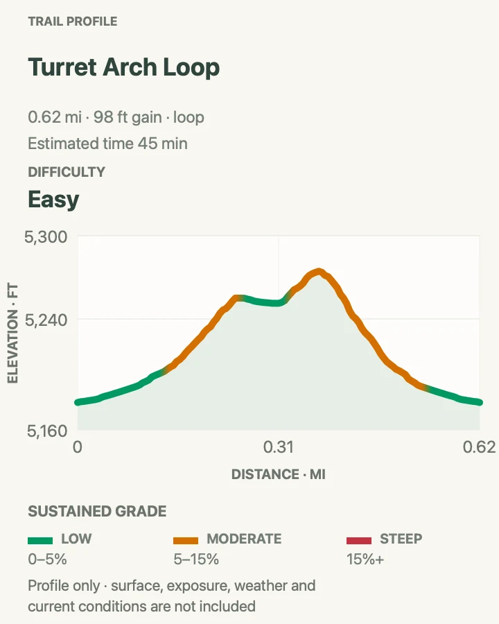
| Turret Arch Loop | 0.6 miles | 20 to 40 minutes | Easy | A focused visit to Turret Arch |
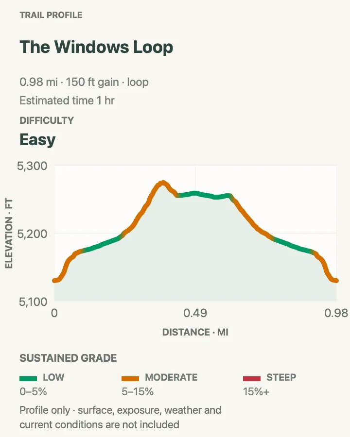
| Windows Loop | 1 mile | 30 to 60 minutes | Easy | Three major arches on an easy circuit |
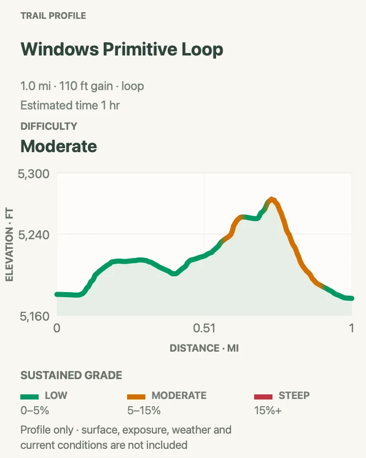
| Windows Primitive Loop | 1 mile for the complete Windows loop | 30 to 60 minutes | Moderate | A quieter, rougher Windows return |
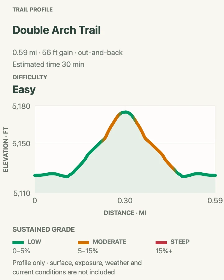
| Double Arch Trail | 0.6 mile round trip | 15 to 30 minutes | Easy | A family-friendly walk to a giant arch |
Turret Arch Loop
- Distance
- 0.6 miles
- Elevation gain
- 100 feet
- Time
- 20 to 40 minutes
- Difficulty
- Easy
- Route type
- Short loop and spur
- Parking
- Use the upper Windows Section parking lot.
- Best time
- Before 9 am or late afternoon, when parking is usually easier and the rock is cooler.
- Pets
- Pets are not allowed. Trained service animals are allowed.
Turret Arch sits slightly apart from the two Windows and rewards a closer look of its own. A short branch from the main trail crosses open slickrock and reaches the base of a large opening beside a smaller companion. The return can be linked into a compact loop with changing views of North Window, South Window, and the surrounding parade of sandstone.
This route overlaps the beginning of the Windows trail, but it works well for visitors with limited time or anyone who wants to concentrate on Turret Arch. Follow the complete loop shown on the map for changing views of all three arches. The upper lot has toilets but no drinking water.
Practical tips
- Walk between the upper and lower lots if you also want to visit Double Arch.
- Do not create shortcuts across soil crust between the established branches.
Terrain and access: Firm trail with slopes and rock steps. Only the opening section of the Windows system is barrier-free.

Windows Loop
- Distance
- 1 mile
- Elevation gain
- 150 feet
- Time
- 30 to 60 minutes
- Difficulty
- Easy
- Route type
- Loop on the main trail
- Parking
- Use the upper Windows Section lot, 12 miles from the park entrance.
- Best time
- Early morning or late afternoon. The lot is often busiest from late morning through midafternoon.
- Pets
- Pets are not allowed. Trained service animals are allowed.
The Windows Loop reaches three of the park’s largest and most accessible arches in one compact walk. The main trail climbs gently toward North Window, crosses beneath the two immense Windows, and branches toward Turret Arch before returning to the lot. Stone steps and firm gravel make the route straightforward, though summer heat and crowding can make it feel harder than the mileage suggests.
North Window invites a close view through the opening, while South Window appears more delicate from the connecting path. Take time to look back toward Elephant Butte, Garden of Eden, and the La Sal Mountains. The parking area can fill for much of the day. An early arrival improves both the walk and the chance of finding a legal space.
Practical tips
- Carry water from the visitor center because none is available at this trailhead.
- Combine the loop with Double Arch by using the signed connector between parking levels.
Terrain and access: The first 300 feet is barrier-free. Reaching the arches requires slopes and rock stairs.

Windows Primitive Loop
- Distance
- 1 mile for the complete Windows loop
- Elevation gain
- 110 feet
- Time
- 30 to 60 minutes
- Difficulty
- Moderate
- Route type
- Main trail outbound, primitive trail return
- Parking
- Use the upper Windows Section lot.
- Best time
- Early morning, with enough light to follow the less obvious back-side route.
- Pets
- Pets are not allowed. Trained service animals are allowed.
The primitive return changes the Windows walk from a busy front-side visit into a more varied loop. After visiting North and South Windows, the trail wraps around the back of the fin on uneven bedrock. The route is quieter and gives a different sense of the size of the formation, but cairns and signs are less frequent than on the main path.
The complete Windows system remains only about a mile, yet the primitive side deserves a moderate rating because its rock steps, ledges, and route-finding require more attention. Follow established markers and resist the apparent shortcuts across fragile soil. If anyone in the group is uncomfortable with uneven terrain, return on the main trail instead.
Practical tips
- Take a photo of the primitive-return sign before leaving the main trail.
- Turn back to the main path if fading light or weather makes the cairns hard to follow.
Terrain and access: The primitive section has uneven bedrock, rock steps, ledges, and fewer markers.

Double Arch Trail
- Distance
- 0.6 mile round trip
- Elevation gain
- 55 feet
- Time
- 15 to 30 minutes
- Difficulty
- Easy
- Route type
- Out and back
- Parking
- Use the lower Windows Section lot near Double Arch. Oversize spaces are limited.
- Best time
- Early morning or late afternoon for cooler temperatures and fewer people.
- Pets
- Pets are not allowed. Trained service animals are allowed.
Double Arch forms where erosion opened two joined spans in the same sandstone mass. The paired openings are visible from the lower parking loop, but their scale becomes clear only near the base. A broad, gently rising trail crosses hard-packed ground before turning sandier beneath the formation.
The official path is easy. Scrambling on the boulders beneath the arch is optional and far more difficult, especially on the way down. Families should stop where the terrain no longer feels secure. The signed connector to the upper Windows lot makes it possible to visit both areas without moving the car, a useful strategy when parking spaces are scarce.
Practical tips
- Remember that climbing up loose boulders is usually easier than getting back down.
- Use the parking-lot connector to add the Windows Loop without searching for another space.
Terrain and access: Hard-packed, gently sloping, and barrier-free with possible assistance. Sand appears near the end.

Delicate Arch and Wolfe Ranch
These three routes all look toward Delicate Arch, but they are not interchangeable. The lower viewpoint is a short accessible look from a distance. The upper viewpoint is a steep half-mile walk that remains across the canyon. Only the Wolfe Ranch trail reaches the base of the arch, and that route crosses exposed slickrock with almost no shade. Choose the version that fits the weather, available daylight, and the group’s comfort.
| Trail | Distance | Time | Difficulty | Best for |
|---|---|---|---|---|
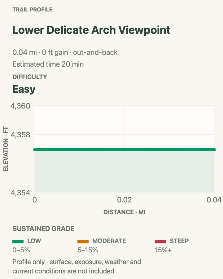
| Lower Delicate Arch Viewpoint | 200 feet round trip | 5 to 15 minutes | Easy | The easiest accessible Delicate Arch view |
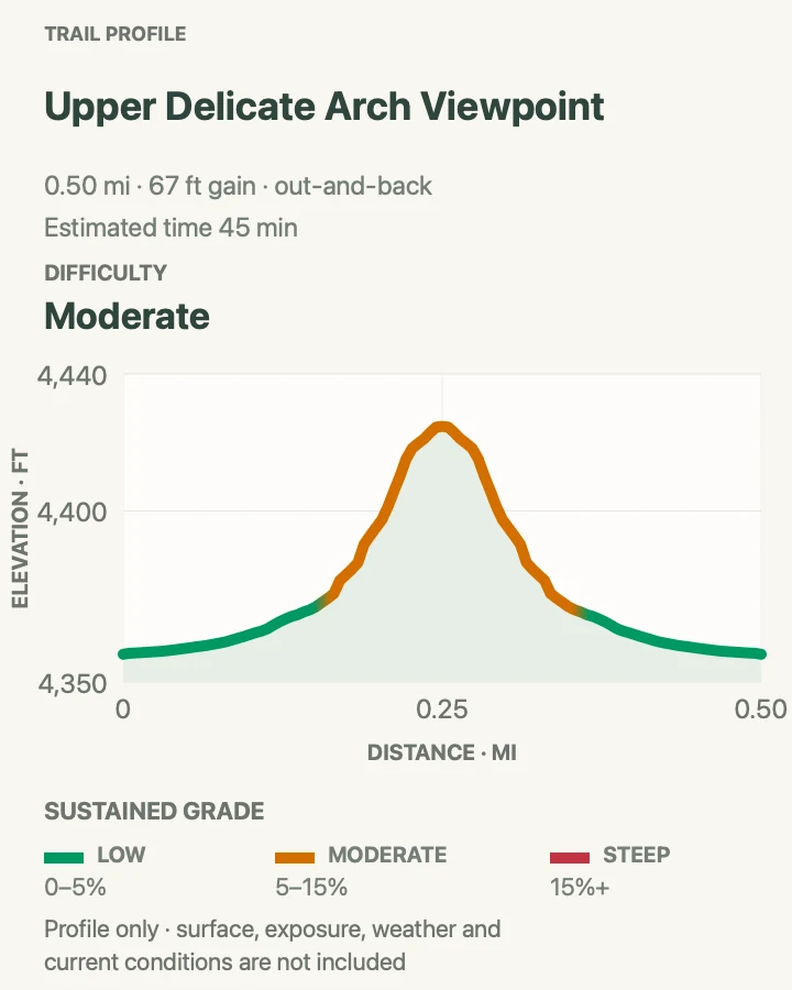
| Upper Delicate Arch Viewpoint | 0.5 mile round trip | 30 to 45 minutes | Moderate | A short climb to a better distant view |
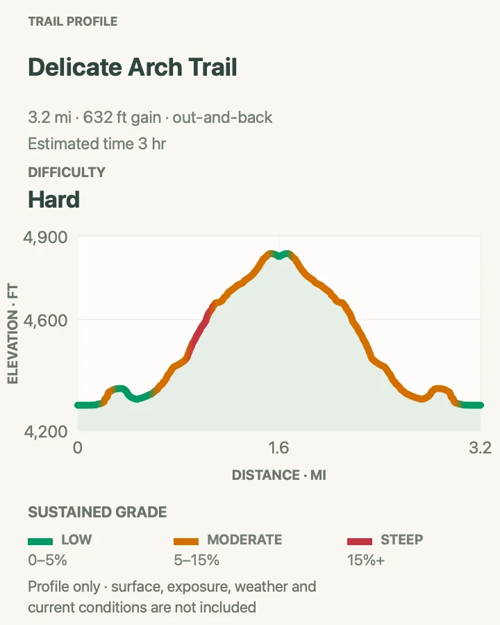
| Delicate Arch Trail | About 3 miles round trip | 2 to 3 hours | Strenuous | Reaching the base of Delicate Arch |
Lower Delicate Arch Viewpoint
- Distance
- 200 feet round trip
- Elevation gain
- 0 feet
- Time
- 5 to 15 minutes
- Difficulty
- Easy
- Route type
- Short out and back
- Parking
- Use the Delicate Arch Viewpoints parking area, which has restrooms and picnic facilities.
- Best time
- Late afternoon for warm light, or whenever a short accessible view is needed.
- Pets
- Pets are not allowed. Trained service animals are allowed.
Lower Delicate Arch Viewpoint is the easiest legal way to see Utah’s famous arch without making the strenuous Wolfe Ranch climb. A broad hardened path leads to a distant view of the opening perched high across the basin. The arch remains about a mile away, so binoculars or a telephoto lens make the stop more satisfying.
This is a viewpoint rather than a substitute for the Delicate Arch Trail. It works especially well for visitors with limited mobility, families working around nap schedules, or anyone arriving after heat has made a longer hike unwise. The nearby upper viewpoint offers a closer angle but adds a steep, rocky climb.
Practical tips
- Bring binoculars because the arch is distant.
- Use this viewpoint when wind, heat, ice, or limited time makes the Wolfe Ranch trail a poor choice.
Terrain and access: Level, wide, hardened, and wheelchair accessible.

Upper Delicate Arch Viewpoint
- Distance
- 0.5 mile round trip
- Elevation gain
- 65 feet
- Time
- 30 to 45 minutes
- Difficulty
- Moderate
- Route type
- Out and back
- Parking
- Use the Delicate Arch Viewpoints parking area.
- Best time
- Morning or late afternoon, with daylight remaining for the rocky descent.
- Pets
- Pets are not allowed. Trained service animals are allowed.
Upper Delicate Arch Viewpoint climbs sharply from the same lot as the lower overlook. The higher perch improves the angle across the canyon, although Delicate Arch still stands about a mile away. The route is short but not gentle. Rock steps, loose footing, and a concentrated climb make it considerably harder than the lower viewpoint.
Choose this trail when you want a more active viewpoint walk without committing to the full Delicate Arch hike. It does not connect to the arch, and trying to cross the canyon is unsafe and damaging. Carry water even for the short outing and save enough light for the descent, where loose gravel demands more care.
Practical tips
- Do not attempt to cross the canyon toward Delicate Arch.
- Use trekking poles only if they help on short rock steps and loose gravel.
Terrain and access: Rock steps, stairs, and steep slopes. Not wheelchair accessible.

Delicate Arch Trail
- Distance
- About 3 miles round trip
- Elevation gain
- 630 feet
- Time
- 2 to 3 hours
- Difficulty
- Strenuous
- Route type
- Out and back
- Parking
- Use Wolfe Ranch. Vault toilets are available, but there is no drinking water. Limited oversize parking is across the road.
- Best time
- Dawn or late afternoon. Avoid midday summer heat, and carry a headlamp for a sunset return.
- Pets
- Pets are not allowed. Trained service animals are allowed.
The Delicate Arch Trail climbs from Wolfe Ranch to the base of the park’s most recognized formation. After the historic cabin and nearby rock-art spur, the route rises steadily over open slickrock. Cairns guide the way across broad sandstone where a dirt tread disappears. The arch remains hidden until the final approach, when a 200-yard ledge wraps around a rock wall and the full opening suddenly comes into view.
The distance is modest, but shade is almost nonexistent and summer heat reflects from the rock. Carry at least two quarts of water per person and wear shoes with dependable grip. Sunset is popular for good reason, yet every hiker needs a headlamp for the dark return. In winter, the final ledge often holds ice and may require traction. Never stand or climb on the arch.
Practical tips
- Save the route map before leaving because cell service is unreliable.
- At sunset, begin the return before the crowd reaches the narrow ledge all at once.
Terrain and access: The opening path to Wolfe Ranch and the rock-art panel is accessible. Beyond it, the trail climbs steep slickrock and crosses an exposed ledge.

Sand Dune, Broken Arch, and Skyline
Short trails and flexible combinations define this section of the park. Sand Dune Arch and Skyline Arch each work as a quick stop. Broken Arch can be an easy grassland out-and-back or a longer loop through fins and Devils Garden Campground. The complete loop earns a separate place because it changes both the terrain and the level of effort, not simply the mileage.
| Trail | Distance | Time | Difficulty | Best for |
|---|---|---|---|---|
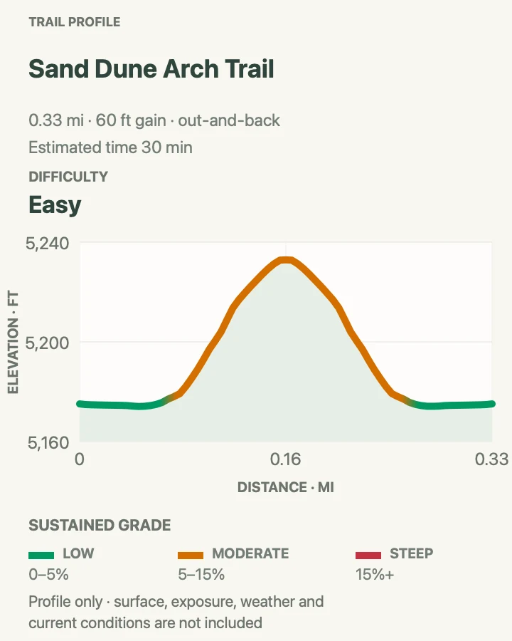
| Sand Dune Arch Trail | 0.4 mile round trip | 15 to 30 minutes | Easy | Shade, deep sand, and a hidden opening |
| Broken Arch Out-and-Back | 1.2 miles round trip | 30 to 60 minutes | Easy | An easy grassland arch walk |
| Broken Arch Loop via Devils Garden Campground | 2.3 miles | About 1 hour | Moderate | A varied loop with light scrambling |
| Skyline Arch Trail | 0.4 mile round trip | 10 to 20 minutes | Easy | A quick stop near Devils Garden |
Sand Dune Arch Trail
- Distance
- 0.4 mile round trip
- Elevation gain
- 60 feet
- Time
- 15 to 30 minutes
- Difficulty
- Easy
- Route type
- Out and back
- Parking
- Use the Sand Dune Arch parking area. A vault toilet is available.
- Best time
- Early or late, although the sandstone fins provide useful shade for part of the walk.
- Pets
- Pets are not allowed. Trained service animals are allowed.
Sand Dune Arch hides inside a narrow gap between tall sandstone fins. The walk is nearly level, but deep red sand makes each step slower than the distance suggests. After squeezing through the entrance, the route reaches a sheltered chamber where the small arch spans the rock above a sandy floor.
The enclosure can feel cooler than open trails, which makes it a useful short option on a warm day. It is also a natural playground, but jumping from the arch or scrambling on the opening is prohibited and unsafe. Continue across the grassland toward Broken Arch if the group wants more mileage, or return to the lot before the sand becomes tiring for young children.
Practical tips
- Empty sand from shoes before continuing to another trail.
- Keep children off the arch and away from blind corners in the narrow passage.
Terrain and access: Deep sand and one narrow passage make the trail unsuitable for wheelchairs.

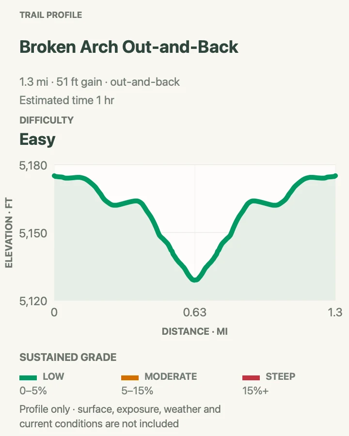
Broken Arch Out-and-Back
- Distance
- 1.2 miles round trip
- Elevation gain
- 50 feet
- Time
- 30 to 60 minutes
- Difficulty
- Easy
- Route type
- Out and back
- Parking
- Use the Sand Dune Arch parking area.
- Best time
- Morning or evening because the grassland crossing is exposed.
- Pets
- Pets are not allowed. Trained service animals are allowed.
The direct Broken Arch route crosses open grassland from the Sand Dune Arch trailhead to a large opening above piñon and juniper woodland. Despite its name, the arch is not split. A fracture near the top creates the broken appearance from some angles. The straightforward out-and-back avoids the campground loop’s rougher scramble.
This is an easy way to add a quieter arch to a Sand Dune stop. The meadow offers little shade, so start before the day becomes hot and watch the sky for thunderstorms. At the arch, turn around if anyone is uncomfortable with the rock beyond the opening. The longer loop continues through it and requires more careful footing.
Practical tips
- Combine the route with Sand Dune Arch before crossing the open field.
- Turn around at Broken Arch for the easiest version.
Terrain and access: Sand, dirt, and uneven rock. Not wheelchair accessible.

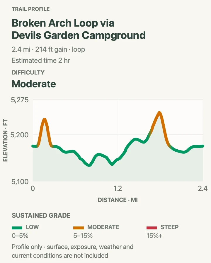
Broken Arch Loop via Devils Garden Campground
- Distance
- 2.3 miles
- Elevation gain
- 210 feet
- Time
- About 1 hour
- Difficulty
- Moderate
- Route type
- Loop
- Parking
- Use the Sand Dune Arch parking area.
- Best time
- A cool morning or late afternoon, with dry rock for the scrambling section.
- Pets
- Pets are not allowed. Trained service animals are allowed.
The complete Broken Arch Loop links three different landscapes in a little more than two miles. Begin with Sand Dune Arch, cross the grassland to Broken Arch, then continue through the opening toward Devils Garden Campground. The return threads among fins, sand pockets, and Tapestry Arch before reconnecting with the trailhead.
This version is more interesting than the simple out-and-back, but it includes ledges and a moderate scramble near Broken Arch. Follow the signs through the campground rather than wandering between occupied sites. Dry conditions matter on the rock steps. If the scramble looks uncomfortable, turn around at Broken Arch and use the easier route instead.
Practical tips
- Follow trail signs carefully through the campground.
- Take the loop only when the rock is dry and everyone can manage the ledges.
Terrain and access: Sand, bedrock, boulders, ledges, and moderate scrambling. Not wheelchair accessible.

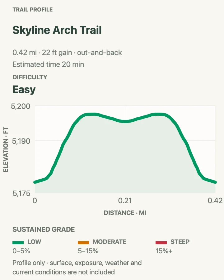
Skyline Arch Trail
- Distance
- 0.4 mile round trip
- Elevation gain
- 20 feet
- Time
- 10 to 20 minutes
- Difficulty
- Easy
- Route type
- Out and back
- Parking
- Use the signed roadside lot near Devils Garden Campground.
- Best time
- Morning or evening. The route is short enough for the edge of daylight if you carry a headlamp.
- Pets
- Pets are not allowed. Trained service animals are allowed.
Skyline Arch sits high in a sandstone wall and appears almost like a window cut into the sky. A short trail climbs gently from the parking area and crosses a relatively level bench to the rockfall at its base. In 1940, a large block fell from the opening and roughly doubled its size, a vivid reminder that these formations continue to change.
The initial steps prevent full wheelchair access, but the campground amphitheater offers an alternate paved view from the opposite side. This is a good leg-stretcher before Devils Garden or a quick final stop on the drive out. Keep clear of loose rock beneath the opening and do not scramble toward the arch.
Practical tips
- Look for the large fallen blocks beneath the opening.
- Use the amphitheater path for an easier alternate viewpoint.
Terrain and access: Mostly level after initial rock steps. A paved alternate view is available from the campground amphitheater.

Devils Garden
Devils Garden is a trail system rather than a single hike. The path to Landscape Arch is easy. Beyond that viewpoint, the route changes abruptly to steep sandstone fins, scrambling, narrow ledges, and exposure. The individual arch spurs provide useful turnarounds, while Double O, Dark Angel, the Primitive Loop, and the circuit with all named spurs demand progressively more time and judgment. Decide on a primary goal before leaving the trailhead and treat every added spur as optional.
| Trail | Distance | Time | Difficulty | Best for |
|---|---|---|---|---|
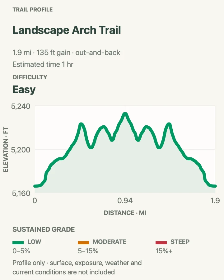
| Landscape Arch Trail | About 1.9 miles round trip | 30 to 60 minutes | Easy | An easy walk to an exceptionally long span |
| Pine Tree and Tunnel Arches Trail | 0.9 miles round trip | 30 to 60 minutes | Easy | Two easy Devils Garden side trails |
| Navajo Arch Trail | 3 miles round trip | Allow 2 to 3 hours | Strenuous | A quiet arch beyond the difficult fin climb |
| Partition Arch Trail | 2.9 miles round trip | Allow 2 to 3 hours | Strenuous | A framed Salt Valley view |
| Double O Arch Trail | About 4.1 miles round trip | 2 to 3 hours | Strenuous | The classic strenuous Devils Garden hike |
| Dark Angel Trail | 4.9 miles round trip by the main trail | Allow 3 to 4 hours | Strenuous | A remote spire beyond Double O |
| Devils Garden Primitive Loop | About 6.6 miles with Dark Angel | 3 to 5 hours | Most difficult | Scrambling and difficult route-finding |
| Devils Garden Loop with All Named Spurs | 7.9 miles | 3 to 5 hours | Strenuous | The complete Devils Garden circuit |
Landscape Arch Trail
- Distance
- About 1.9 miles round trip
- Elevation gain
- 130 feet
- Time
- 30 to 60 minutes
- Difficulty
- Easy
- Route type
- Out and back
- Parking
- Use Devils Garden, which has toilets year-round and drinking water from spring through fall.
- Best time
- Early morning, when the arch catches good light and the trail is quieter.
- Pets
- Pets are not allowed. Trained service animals are allowed.
Landscape Arch is the easiest major destination in Devils Garden. A broad hard-packed trail winds between fins and low desert vegetation before reaching a clear view of the impossibly thin span. The opening measures more than 300 feet across, while the narrowest part of the ribbon is only a few feet thick.
Large pieces fell from the arch in the 1990s, and visitors now remain at designated viewpoints rather than walking beneath it. Morning light brings out the warm color and usually arrives before the parking lot reaches its busiest period. The trail beyond Landscape Arch becomes immediately harder, with steep sandstone, narrow ledges, and exposure. Turn around here unless everyone is prepared for that change.
Practical tips
- Treat Landscape Arch as the turnaround for an easy Devils Garden hike.
- Use the nearby Pine Tree and Tunnel spurs if another easy half mile sounds appealing.
Terrain and access: Hard-packed and generally barrier-free, though the final slopes may require assistance.

Pine Tree and Tunnel Arches Trail
- Distance
- 0.9 miles round trip
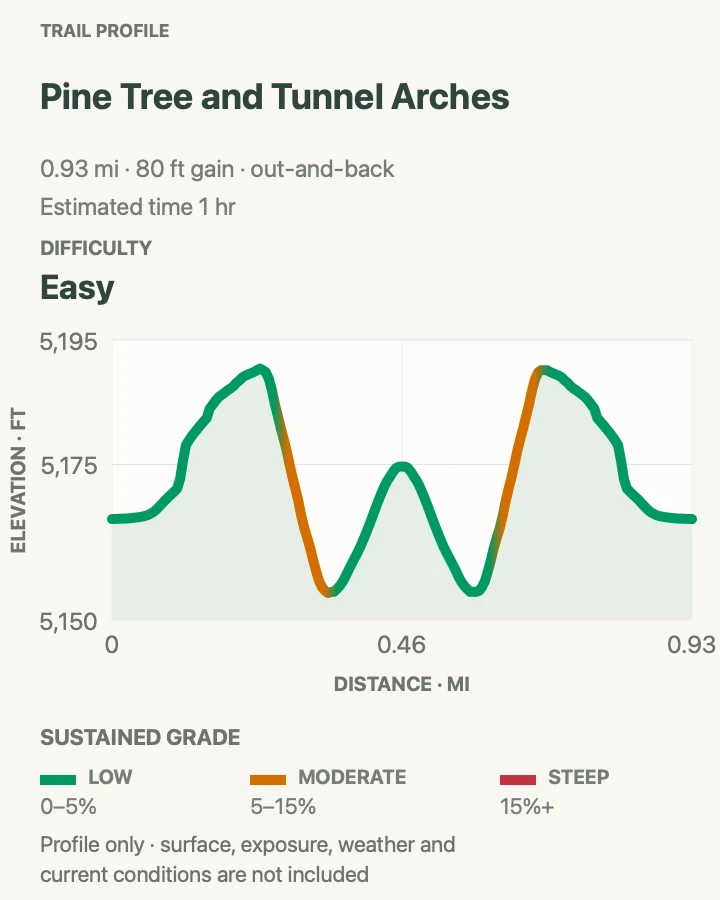
- Elevation gain
- 80 feet
- Time
- 30 to 60 minutes
- Difficulty
- Easy
- Route type
- Branched out-and-back spurs
- Parking
- Use Devils Garden.
- Best time
- Early morning before the main Devils Garden corridor becomes busy.
- Pets
- Pets are not allowed. Trained service animals are allowed.
Pine Tree Arch and Tunnel Arch sit on two short branches near the beginning of Devils Garden Trail. Tunnel Arch is viewed from below as an opening high in a fin. Pine Tree Arch is larger and more intimate, with a sandy approach framed by juniper. Hiking both branches from the trailhead creates the short outing shown on the map. Adding the same branches to a Landscape Arch hike adds about half a mile.
These spurs are useful when the main path feels crowded because many visitors walk straight past the junction. The terrain is easier than the route beyond Landscape Arch, though sand and uneven rock still require normal hiking footwear. Visit the branches on the way out or save them for the return if the group wants to decide after seeing Landscape Arch.
Practical tips
- Follow the signed branches rather than cutting between them.
- Save the spurs for the return if heat or energy will determine the final distance.
Terrain and access: Hard-packed gravel, sand, and rock. The separate spurs are not fully accessible.

Navajo Arch Trail
- Distance
- 3 miles round trip
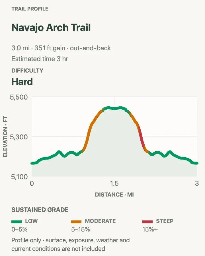
- Elevation gain
- 350 feet
- Time
- Allow 2 to 3 hours
- Difficulty
- Strenuous
- Route type
- Out and back with a spur
- Parking
- Use Devils Garden.
- Best time
- At dawn on a dry day. Avoid wet or icy sandstone.
- Pets
- Pets are not allowed. Trained service animals are allowed.
Navajo Arch occupies a cool recess behind a sandstone fin in the harder half of Devils Garden. Reaching it requires the steep climb beyond Landscape Arch, including sloping sandstone and exposed sections of the main route. A signed spur then turns into a quieter sandy corridor and passes beneath the broad opening.
The final spur is not the hardest part. The approach gives the complete hike its strenuous rating, so do not choose it as an easy alternative to Double O. Navajo and Partition arches together add about 0.8 mile to the main route. This outing turns at Navajo Arch, with its mileage and gain following the line shown on the map. Avoid the exposed approach when rock is wet or icy.
Practical tips
- Assess comfort on the first fin climb before committing to the spur.
- Add Partition Arch only if daylight, water, and energy remain comfortable.
Terrain and access: The approach beyond Landscape Arch requires steep slickrock, scrambling, narrow ledges, and exposure.

Partition Arch Trail
- Distance
- 2.9 miles round trip
- Elevation gain
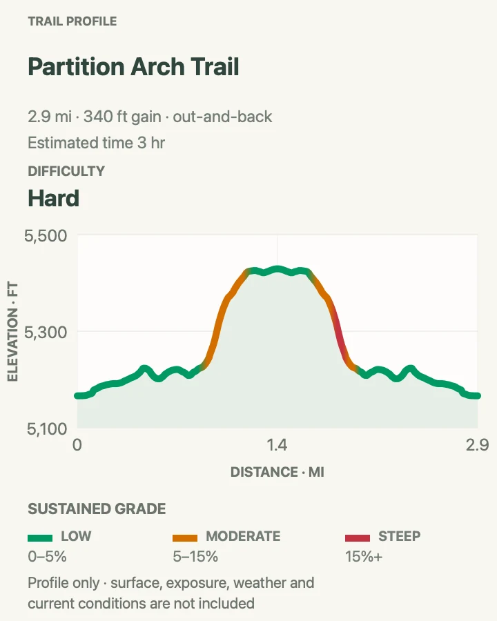
- 340 feet
- Time
- Allow 2 to 3 hours
- Difficulty
- Strenuous
- Route type
- Out and back with a spur
- Parking
- Use Devils Garden.
- Best time
- Early morning on dry rock.
- Pets
- Pets are not allowed. Trained service animals are allowed.
Partition Arch opens through a high fin and frames a broad view across Salt Valley. The branch leaves the main Double O route beyond Landscape Arch, after the trail has already climbed steep sandstone and crossed exposed terrain. A short final spur reaches the paired opening and a small area where hikers can rest without blocking the path.
This is a rewarding turnaround for hikers who want the difficult Devils Garden experience without continuing all the way to Double O. The approach remains strenuous. Navajo and Partition arches together add about 0.8 mile to the main route. This outing turns at Partition Arch, following the line shown on the map and profile. Stay away from the edge around the opening and never climb on the arch.
Practical tips
- Keep packs and feet back from the drop below the opening.
- Return the way you came rather than following unmarked ledges.
Terrain and access: The route beyond Landscape Arch has steep slickrock, ledges, scrambling, and exposure.

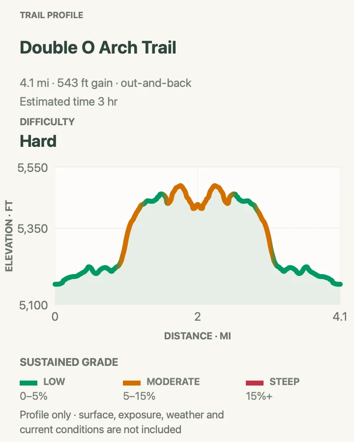
Double O Arch Trail
- Distance
- About 4.1 miles round trip
- Elevation gain
- 540 feet
- Time
- 2 to 3 hours
- Difficulty
- Strenuous
- Route type
- Out and back
- Parking
- Use Devils Garden.
- Best time
- Early morning, before the fins heat up and the lot fills.
- Pets
- Pets are not allowed. Trained service animals are allowed.
Double O Arch is the classic strenuous destination in Devils Garden. Past Landscape Arch, the easy gravel gives way to a steep sandstone fin. Hikers use hands and feet in places, walk along narrow sloping rock, and follow cairns across sections where the route is not obvious. The destination consists of two stacked openings, with the smaller O below the much larger span.
Carry at least two quarts of water per person and turn around if exposure on the first major fin feels wrong. Navajo and Partition arches are optional side trips, not required parts of the main route. The return follows the same difficult terrain unless continuing onto the primitive loop. Wet sandstone, snow, and ice make the route unsafe.
Practical tips
- Use the first exposed fin as an honest test of the group’s comfort.
- Do not descend the primitive trail unless it was part of the original plan.
Terrain and access: Rock scrambling, narrow ledges, steep drop-offs, and uneven sandstone beyond Landscape Arch.

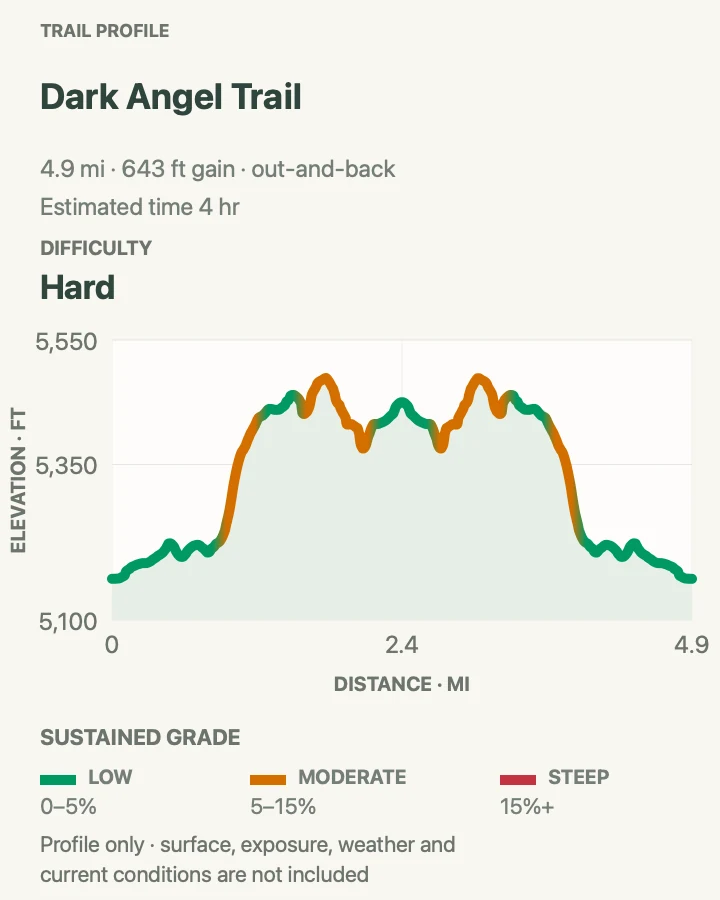
Dark Angel Trail
- Distance
- 4.9 miles round trip by the main trail
- Elevation gain
- 640 feet
- Time
- Allow 3 to 4 hours
- Difficulty
- Strenuous
- Route type
- Out and back
- Parking
- Use Devils Garden.
- Best time
- At dawn, with enough daylight for the exposed return.
- Pets
- Pets are not allowed. Trained service animals are allowed.
Dark Angel extends the Double O hike to a remote sandstone spire at the northern end of Devils Garden. The extra spur begins beyond Double O and crosses open terrain toward the dark monolith visible in the distance. The destination is a spire, not an arch, and the quieter setting often feels far removed from the busy trailhead.
The main-trail out-and-back totals 4.9 miles and repeats the exposed fin crossings on the return. Start early, carry more water than the mileage seems to require, and keep enough energy for the difficult descent beyond Landscape Arch. The primitive return is a separate, harder commitment. Do not drift onto it unless the group has the map, time, and conditions to complete that loop.
Practical tips
- Look for Dark Angel as a freestanding spire rather than an arch.
- Check the turnaround time before leaving Double O.
Terrain and access: Includes the difficult Double O approach, followed by an exposed spur through sand and slickrock.

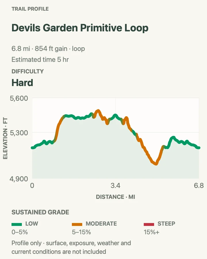
Devils Garden Primitive Loop
- Distance
- About 6.6 miles with Dark Angel
- Elevation gain
- 850 feet
- Time
- 3 to 5 hours
- Difficulty
- Most difficult
- Route type
- Main trail outbound, primitive trail return
- Parking
- Use Devils Garden.
- Best time
- Begin at dawn on a dry day. Never use the primitive trail on wet or icy rock.
- Pets
- Pets are not allowed. Trained service animals are allowed.
The Primitive Loop turns the Double O and Dark Angel outing into one of the park’s most demanding marked hikes. The complete 6.6-mile route follows the main trail to Double O, visits Navajo and Partition arches, continues to Dark Angel, and returns through the primitive section. That return crosses deep sand, sloping slickrock, narrow ledges, and a pool that may contain water. Cairns are sparse enough that route-finding is part of the challenge.
This is not a shortcut or an easier way down. Avoid it when rock is wet, snowy, or icy, and skip it if anyone dislikes heights. Private Arch sits on an optional spur from the primitive route. Carry at least three quarts of water, a headlamp, and an offline map. If the day is running late at Double O, return on the familiar main trail.
Practical tips
- Confirm the primitive-trail junction before leaving Double O.
- Treat standing water, wet slickrock, or lost cairns as reasons to turn back.
Terrain and access: Difficult route-finding, steep slopes, narrow drop-offs, scrambling, deep sand, and a pool that may hold water.

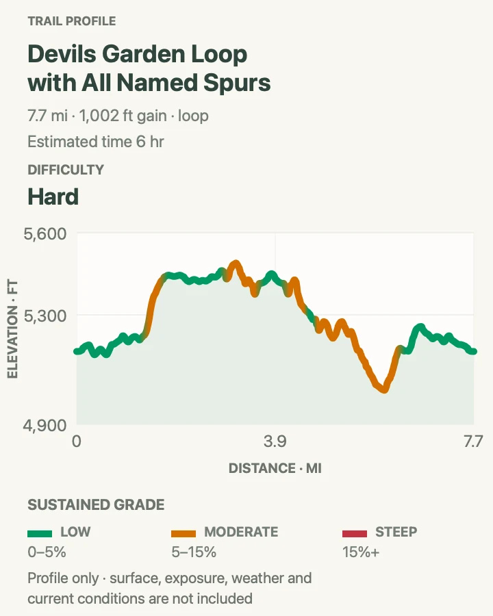
Devils Garden Loop with All Named Spurs
- Distance
- 7.9 miles
- Elevation gain
- 1,000 feet
- Time
- 3 to 5 hours
- Difficulty
- Strenuous
- Route type
- Loop with all named arch spurs
- Parking
- Use Devils Garden.
- Best time
- Start at dawn with a dry forecast and a firm turnaround plan.
- Pets
- Pets are not allowed. Trained service animals are allowed.
This loop strings together every named spur in Devils Garden. Pine Tree and Tunnel arches branch from the easy opening section. Landscape Arch marks the end of the gentle trail. Beyond it, the route climbs to Navajo, Partition, and Double O arches, reaches Dark Angel, visits Private Arch, and returns by the primitive trail.
The 7.9 miles understates the concentration required. Exposed fins, route-finding, repeated side trails, deep sand, and summer heat slow the pace. Begin at dawn, carry at least three quarts of water per person, and pack a headlamp and light layer. If heat, weather, or fatigue erodes the safety margin, drop a spur and accept that the day will be shorter than the full loop with all named spurs.
Practical tips
- Know the order of the spurs before leaving the easy trail so none is missed.
- Leave the primitive trail for another day if weather or timing becomes uncertain.
Terrain and access: All difficult Devils Garden terrain, including exposed fins, scrambling, primitive route-finding, sand, and optional spurs.

Fiery Furnace and Klondike Bluffs
The park’s two most logistically demanding outings sit far apart. Fiery Furnace requires a reservation or permit and involves maze-like navigation. Tower Arch requires an unpaved approach whose condition can change after a single storm. Neither is a spontaneous substitute when a paved-road lot is full. Confirm the permit or road first, then carry enough water for slow travel through complex terrain.
| Trail | Distance | Time | Difficulty | Best for |
|---|---|---|---|---|
| Fiery Furnace | Variable by permitted route | About 2.5 hours for the ranger-led loop | Strenuous | A permitted sandstone maze |
| Tower Arch Trail | 2.6 miles round trip | 2 to 3 hours | Strenuous | Remote fins and deep sand |
Fiery Furnace
- Distance
- Variable by permitted route
- Elevation gain
- Variable by permitted route
- Time
- About 2.5 hours for the ranger-led loop
- Difficulty
- Strenuous
- Route type
- Ranger-led loop or permitted self-guided exploration
- Parking
- Meet or park at Fiery Furnace Viewpoint, 15 miles beyond the visitor center. Restrooms are available, but there is no water.
- Best time
- Use the reserved tour time. Self-guided permits are valid only from sunrise to sunset.
- Pets
- Pets are prohibited. Trained service animals may face terrain that cannot be safely negotiated.
Fiery Furnace is a maze of narrow passages between tall sandstone fins rather than a conventional trail. Small markers identify one counter-clockwise route, but dead ends and intersecting corridors make it easy to become disoriented. GPS reception is unreliable inside the walls. The map labels Surprise Arch, Skull Arch, and Kissing Turtle Arch as landmarks, not navigation instructions. First-time visitors are best served by a ranger-led hike or an experienced permitted companion.
Every entry requires a reservation for a ranger tour or a self-guided permit. The ranger loop lasts about two and a half hours and requires scrambling, squeezing through narrow gaps, crossing loose sand, and moving beside drop-offs. Self-guided distance and elevation vary because there is no single route through the maze. Carry at least one quart of water, wear gripping shoes, and keep both hands free.
Practical tips
- Reserve before the visit and complete the required in-person permit pickup and orientation.
- Do not use the map as turn-by-turn navigation inside the maze.
Terrain and access: Irregular sandstone, narrow ledges, loose sand, jumps, tight squeezes, and sections requiring hands and feet.

Tower Arch Trail
- Distance
- 2.6 miles round trip
- Elevation gain
- 570 feet
- Time
- 2 to 3 hours
- Difficulty
- Strenuous
- Route type
- Out and back
- Parking
- Use the Klondike Bluffs trailhead after 8 miles of unpaved road. Check road conditions before leaving the pavement.
- Best time
- At dawn, before the exposed valley and sand hills become hot.
- Pets
- Pets are not allowed. Trained service animals are allowed.
Tower Arch lies in the quiet Klondike Bluffs area, far from the paved-road trailheads. The route begins with a steep climb over a rock wall, crosses an open valley, and winds among fins and sand dunes before reaching the broad opening. Marching Men, a row of narrow towers, adds to the sense of isolation.
The hike is strenuous because deep sand and the opening climb demand more energy than the mileage suggests. The approach requires eight miles on Salt Valley Road, which is normally suitable for two-wheel-drive vehicles only in good conditions. Rain or snow can quickly make it four-wheel-drive only or impassable. Carry at least two quarts of water, expect no cell service, and turn back rather than testing a damaged road.
Practical tips
- Ask at the visitor center about Salt Valley Road before committing to the drive.
- Download the map and tell someone the plan because cell service is unreliable.
Terrain and access: Steep bedrock, rock ledges, deep sand, a difficult sand hill, and no dependable cell service.

A final check at the trailhead
Look at the sky, read every posted sign, and compare the route with the water and daylight actually available. If the lot is full, do not invent a space. If sandstone is wet, choose a firm short trail. If the temperature is already climbing, save an exposed route for another morning. Arches rewards flexibility. A quiet half-mile walk made at the right time is better than forcing a long route after the safe window has closed.
Map data © OpenStreetMap contributors. Trail geometry includes National Park Service public trail data.